This transcript is provided by Catharine Inniss & the Cottage in Muskoka Editorial Team as an informal resource for cottagers, residents, and anyone following the Clevelands House / Minett redevelopment and OPA 64.
It has been lightly edited for readability, speaker identification, and place names (for example: Minett, Lake Rosseau, Clevelands House). It is not an official record of the meeting. There may still be errors, omissions, or sections where the audio was unclear. Nothing here should be taken as legal advice or as a substitute for the official planning documents, Township of Muskoka Lakes or District of Muskoka materials, or Ontario Land Tribunal (OLT) decisions.
If you quote or share this transcript elsewhere, please credit Cottage in Muskoka and include a link back to this page. Preparing, cleaning, and formatting transcripts like this takes a significant amount of time, and linking back helps more people find a reliable record of the meeting and encourages us to keep publishing resources like this, alongside our coverage of other developments in Muskoka.
Clevelands House Planning Meeting Transcript
Below is the full transcript from today’s Township planning meeting on the Clevelands House redevelopment on Lake Rosseau. If you’re looking for the full background, timeline, and key documents, you can find all of that on our Clevelands House redevelopment overview.
This post is very much a “transcript as promised” so people can search, quote, and double-check specific details. I’ll be pulling out the main takeaways and breaking them into shorter, more digestible posts soon, so if you’re not an “I want every single detail” person, check back tomorrow.
Part 1, Paula Bustard & Andrew Seymour
Chair Bosomworth – Opening and Housekeeping
Welcome to the Special Planning Committee of the Township of Muskoka Lakes. And we’re here for a very important topic, the presentation, public meeting for the application for the Village of Minett by SmartCentres.
I know there’s a lot of interest in that, and the point of this today is to get input from the public. There have been no decisions being made today. So I know there’s lots of public interested in this. And so those present and those online, we encourage you to speak up and tell us what you think about it, as it’s a legal part of the process for any development that we do. And so I welcome the team from SmartCentres. They’ve come up this morning.
And I call the meeting to order at 9:02, I think it is. Let’s call it 9:02. I will confirm that we have members of—we have a quorum. We have one who will not be attending today. And I think we’re still short of one councillor. We have the CAO, Clerk, Director of Development Services and Environmental Sustainability, and another member of our staff present.
We did get a—we asked for public input through our email of planning@muskokalakes.ca. We have invited SmartCentres, and I think it’s mainly Paula Bustard and Carmen Caravaggio—I got that correct. So they are invited delegates, and the purpose of that is to not limit them to five minutes. I don’t think anybody would want them to be limited to five minutes.
And also, as part of the supplementary agenda with some of the other people representing the applicant, and they, I believe, are online. Today’s meeting is being live streamed and recorded on the Township of Muskoka Lakes’ website and YouTube channel. And by participating in the open public meeting today, you are consenting to your image, voice, and comments being recorded and posted online.
We’ll ask committee if anybody has any pecuniary interests. Very well, seeing none. We are going to—yeah. All right. So that’s it for now. Right on the agenda is Ms. Bustard.
Paula Bustard – Introduction and Master Plan Overview
Thank you. It would help if I turn it on. I apologize. We’re very excited to be here today to walk you through our vision for Clevelands House and the proposed redevelopment. With me today is Mitchell Goldhar, owner of the property. He’s here to answer any questions that you may have following the presentation.
I also have members of our team, including Andrew Seymour, who heads up our engineering and construction, who will speak shortly in this presentation. We also have our team from Azimuth, who’s our environmental engineers. Lastly, all of our other consultants are online and available if there’s any technical questions. So thank you very much. If you can go to the next slide, please. Just starting with an overview of the area of the property. I think this property is very well known to many.
The overall acquisition was over 1,300 acres of land. But obviously, what we’re here to talk about today is phase one and the overall Minett OPA area, OPA 56. Next slide, please. The existing Clevelands House Resort has been around since the late 1800s. The site’s been developed for resort, marine, golf, boating, and a whole array of uses for the last 100 years.
As you can see, there’s been significant development along the shoreline and obviously all the different components we’ve discussed. Next slide, please. There’s just some visions or some photographs of the existing site, which I believe many of you are familiar with: some cabins, the overall aerial, and the pier. Next slide. And the existing marina and marina buildings. Next slide, please.
Since 2018, we’ve put together an impressive consulting team to work with us on overseeing the vision and the design of the site. Our consulting team is led by Neil McLaughlin, who’s our architect out of London, England. Neil is a world-renowned architect who really has a focus on craftsmanship, materiality, and really sense of place in creating buildings. And he’s really worked hand-in-hand with Mitch and with the team on the evolution of the plan and the design. Next slide, please.
Our master plan is before you right now on the slide. Many of you attended our public consultation in Minett back in November 2023, where we first unveiled our proposed master plan. Since that time, we have been working closely with the Town and various peer reviewers and the community on technical components of the application. Except for a very, very small modification, which I’ll explain to you shortly, the plan has remained unchanged in that time period.
The focus has always been on creating meaningful and thoughtful experiences for both visitors and residents alike, providing access and immersion in nature, providing access to community gathering spaces, and, of course, beautiful architecture. We’ve worked with our design teams on designing buildings with natural materials set into nature, really focusing on tree preservation where possible, and really creating a walkable community where people from the lake visiting the site or visitors from outside the community can really jointly experience the property and all the different amenities.
Paula Bustard – Phase 1 Components and Stats / OPA 56 Context
Next slide, please. What I’d like to walk you through now is phase one, which is the subject of the application, the rezoning application. Phase one is outlined in red and really is encompassing the bulk of the area of the Clevelands House Resort and the existing marina. Next slide, please. This is the site plan for phase one. There are four main components of phase one. On the left of the screen, you’ll see 48 cabins.
These cabins have been meticulously designed and positioned to maximize privacy and, again, access to nature and walkability. The 48 cabins then connect to the tennis facility. There’s a tennis pavilion, indoor and outdoor courts, and other athletic components to the site. The third component is the village and the wellness centre, which is on the right-hand side, providing, obviously, access for the community to access the site, community gathering spaces, office, wellness, and retail.
The last component is the marina services, so docking, boating, and boat storage. Next slide, please. And this is just a massing model, just showing you a little bit of an aerial view. Shortly, I’m going to show you some more renderings so you can get more feel for the character of the site. But here you can see that one of our strong principles is walkability, preservation of trees, and really connectivity of each of these components and how they work together, and really respecting the past, but making this a place for the future that people can truly enjoy.
Next, I’m just going to get into a little bit of the stats of phase one so you can understand a little bit more of the details. Before we go to the next slide, I think it’s just a good opportunity to talk about OPA 56, which is obviously the OPA governing the site and the Village of Minett. When Mitchell purchased this property, the existing permissions that ran with this land were in excess of 4,000 units with really no hard, fast GFA cap.
One of the things that we did is work on the Minett Steering Committee and work hand in hand with the Town, with the District, and with the community on the creation of OPA 56. Through OPA 56, many, many concessions were made completely voluntarily about, obviously, modifying the existing permissions. The GFA was capped on the site to 1.7 million square feet, which was not capped previously. The amount of units on the site, we agreed to reduction to 1,999, which was more than half of a reduction of what ran with the property at the time of acquisition.
There’s also a lot of policies in the OPA which further restricted the site. We agreed to unit equivalences, capping of GFA, phasing provisions, public servicing requirements, docking caps, and many other policies that restricted the use of the land. And this was all done and agreed to in collaboration with all the parties. And that’s really the basis for which the master plan was created and is presented before you today. Next slide. These are the stats for phase one.
And I will just very quickly walk you through some details. Next slide. Again, just bringing you back to the overview of the site. Next slide, please. The area of phase one is covered off in VC, RC1, and RC2 parts of OPA 56. Within that area, the total permitted GFA allowed is 750,000 square feet and 882 units. Next slide.
Just looking at our phase one plan, it doesn’t encompass the entirety of VC and RC1 and RC2, but it takes up about 46% of that area. We are proposing, as part of phase one, 48 cabins. And in total, between the village, the marina buildings, and the cabins, the total GFA is 199,000 square feet. Next slide.
So, in looking at globally what’s being proposed just in VC, RC1, and RC2, what we are proposing is 6% of the permitted units, 26.6% of the permitted GFA on 46% of the land. Next slide. And then just to bring that back into the broader entire OPA area that includes our lands in R2 and R1. The overall land holdings there are 367 acres.
There is no application made at this time for anything beyond phase one, but anything outside of phase one will be subject to a full rezoning application, full technical review, future public consultation. So everything will go through a public process at that time. But if you look at phase one in the context of the existing as-of-right permissions that run with the land, we are talking about 2.7% of the permitted units, 11% of the permitted GFA, on 7.6% of the lands. Next slide.
Paula Bustard – Environmental Work and Micro Cabins in Wetlands
One of the big principles of this development is having a very light touch and making sure that there’s meaningful development while respecting nature. As part of that, we have done extensive environmental studies. Azimuth is with us today. They have actually worked on the site since 2002, long before we acquired it. Through the acquisition, we went back to the team that had obviously done extensive historical work on the site, and we engaged them to do all of our future studies.
So there’s a lot of work that was done previously, but since 2018, there’s a list here. I won’t read all of them out. But in pretty much every calendar year, we’ve been doing a lot of different site investigations, habitat analysis, looking at the different nesting seasons, looking at all the different components that need to be done from an environmental perspective, which all formed part of our EIS, which has since been peer-reviewed and which obviously is subject to further review by the Town. Next slide.
So I said to you before that one of the fundamental principles of our master plan was respecting OPA 56, which is true. And there’s one component—our plan has never changed: the micro cabins along the wetlands. It was always on our master plan, but through the technical review, it was determined that there should be a policy amendment to the OPA if they were to be permitted. So one of the things we’re here today for is not just our zoning application, but a technical OPA to allow for the micro cabins along the wetlands.
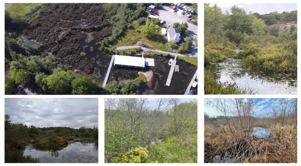
I know that issue in itself may be slightly contentious, so I want to explain a little bit more the vision for that and why this came about. So to ensure that lands are seamlessly integrated into the master plan and restored to their historical functionality, we are making this request. I’d like to show you some current photos. The one before you here is an aerial shot looking at the wetlands towards the floating yoga studio. The current state of the wetlands are a hazard. They are not conducive to creating a family-friendly resort and a walkable, inviting educational experience and amenity for the community.
These lands are central to the site plan and a critical component of creating a world-class experience. Cleaning up and restoring the open marsh functionality of the wetlands is essential for the viability of the resort. The current state of the wetlands, as seen in this picture before you today, is a very, very dense thicket, tall vegetation surrounding the majority of the wetlands. It creates a dangerous environment for children, and views of the wetlands are extremely obstructed by the thicket and vegetation.
Access to the water is dangerous and unpredictable, as thick vegetation creates uncertainty on water depth and boundaries. We have the opportunity here to create a cohesive plan that blends together the amenities for the community and a peaceful resort for traveling families, focused on nature and walkability. The plan before you today, with the purposeful light touch and low density, is predicated on the ability for these wetlands to be integrated and restored to a safe, approachable environmental feature that encourages access, education, and experience.
We want to restore its historical functionality of an open marsh and a shallow back bay. The alternative is creating a physical barrier around the wetlands, which would eliminate any natural pedestrian flow and connectivity. It would also limit view corridors and sight lines. This approach would nullify the vision before you today and make the plan simply unviable. Next slide. These are some other views of the existing wetlands. The entire site of the wetlands has been subject to modifications and adjacent development for over 100 years.
The wetland is located beside a previous golf course. Drainage to the wetlands has been altered numerous times. Beaches have been added to the property, which have limited the flow of water out of the wetlands. Bridges and other structures have been built on the wetlands as well. If you look at the screen here, you’ll see one such example as the existing floating yoga studio. This is a very unique experience and highly valued by many members of the community. If you go there on a summer day, it’s a bustling hub of activity.
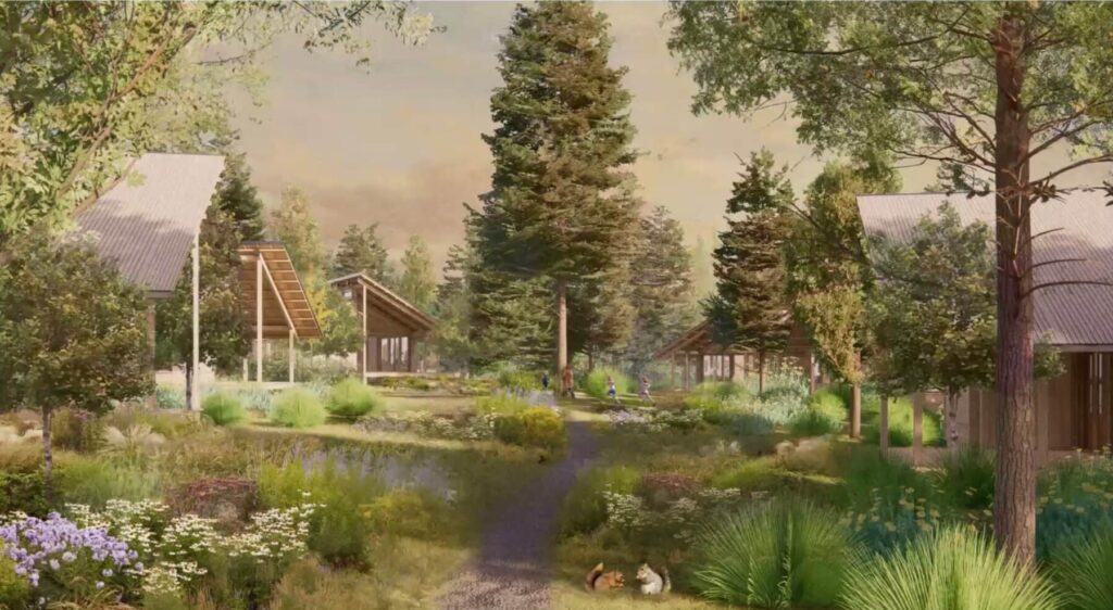
Under the current policies, although this is legal non-conforming, this would not be permitted and would be deemed as an encroachment. Unique experiences like this are what we’re trying to create in terms of blending the village and the cabins and the experience for all parties. I’d like to now show you what our vision of a restored wetland can look like and the opportunity of improving its functionality from thick, dense thicket to open marsh. Next slide. Some individuals may speak today about the loss of habitat wetland.
What we’re proposing is a change, but is in our opinion an improvement to the wetland and not the removal of the wetland in any way. I do acknowledge it requires the alteration and removal of the dense thicket and the vegetation, which by environmental standards is considered lost habitat. However, it also creates the opportunity for new habitats to flourish in its place. When looking at the overall plan with the vision holistically, we believe the trade-off is without question for the betterment of the site and the betterment of the community at large.
As stated previously, these changes provide access to the wetland by the broader public, creating educational opportunities. It seamlessly blends together the various components of the marina, the village, and the tennis, and the woodland cabins. It creates meaningful, walkable, beautiful, and more importantly, safe environments for families. This change is not only an improvement, but a necessary change for the vision and viability of the future resort. These wetlands are roughly 5% of the overall phase one area.
They’re 0.9% of the overall OPA area and 0.25% of the overall land holdings. This is a vision from the bridge connection that would obviously connect the wellness centre over to the cabins. Next view. And the next slide, this is a vision from the village looking across the wetlands to the cabins. Next slide, please. To put in perspective, the modifications we are seeking would permit the following units in orange to be constructed along the wetland and within the use limitation zone.
A thoughtful and sensitive approach would be taken to construction, but it would create a unique and world-class identity for the development. Next slide, please. I did mention earlier there was one small change on the site plan, and that’s what’s before you here. Just north of the wetland, the original proposal called for a reflection pond, and that was in a lot of the imagery that was being shown. Through the technical review, it was determined that there was some concern the reflection pond might impact some of the functionality of the wetland.
We went back to the drawing board with our team and modified that to a woodlot—a woodland, excuse me—that would then obviously blend into the indoor courts. Not only does this help the functionality of the wetland, but it also allows us to preserve more trees. So next slide, please. So this is the main change. That was the original vision, connecting into the village across a reflection pond. Next slide. And the alternative is keeping it as a woodlot, maximizing tree preservation and, obviously, new plantings, which we think is a great change for the plan and was done hand-in-hand through the technical review.
Paula Bustard – Cabins, Tennis Pavilion, Village, Heights, and Lighting
Next slide, please. All right. And just to wrap up my section of this, I’m just going to walk you through some of the visions of the overall site. Next slide. I’m going to start with the cabins, which I’ve spoken about. I did speak about there being 48 cabins, but also remember there’s that policy of unit equivalences. So when you use the unit equivalences, we’re doing 54 units. And all of the stats I gave you were based on the 54 and not the 48. All right. Next slide.
These are just some renderings of the cabins. Obviously, placing them in nature, very unique architecture, use of a lot of natural materials. We’ve worked with the architect about the positioning of the cabins to maximize privacy and sight lines so that they’re uniquely placed throughout the site. Next slide. Just some more visions of obviously creating walking trails, creating connections between the cabins, boardwalks along the water, view corridors again from gathering spots, looking over the wetlands into the village.
There you see the steeple of the church, which will be maintained on site, and the different types of cabins, some stilted, some at grade, and really unique architecture and creating meaningful experiences for people who will rent these. These will also be fully rented out throughout the year. Next slide. These are some renderings of the cabins. We actually did a test mock-up of a construction of one of these, which some people have seen pictures of, really looking at the materiality, the constructability of it.
Again, I’ve used this term a lot, but a lot of craftsmanship that Neil and his team have put into the creation of these cabins, both the interior and the exterior. Next slide. These are just some of the different cabins. The top right one is the stilted cabin. That would be the micro cabin on the wetland. And just some of the unique cabins that will be placed through the site. Next slide. Next, I’m going to show you the tennis pavilion. Next.
As we traverse through the site, a really, really beautiful tennis pavilion, a centre court, array of courts. Then there’ll be buildings with indoor courts, squash, basketball, a lot of athletic components, both for the general public and for the traveling community. Next slide, please. And lastly, the village. Next slide. The village has been meticulously designed really to be a hub of activity for the community and for the traveling public.
You can see that there’s generous gathering spaces, amphitheatres, plaza squares, which will allow for events, will allow for, obviously, community gathering. The village itself will have retail, office spaces, dental, medical, physiotherapy. There’s a wellness centre, squash, yoga, everything tying into the tennis and to the overall usability of the site. Next slide. That’s the ground floor. Those are the second-floor components. One thing which I’ll show you in a moment as well that has been spoken to about us is height and view from the canoe.
So I’m going to show you, obviously, the village ramps up because the road at the back there is at a higher elevation. But everything on this site has been designed very, very consciously from what is the view from the lake, what is the view of the people experiencing the site, really trying to blend everything into nature as much as possible with a few moments of obviously creating a sense of place. Next slide. This is some of the character of the village, whereas the cabins are predominantly wood. The village has a lot of stone and wood, really creating a blend of natural materials.
Next slide. And this is a view from the lake, which I was talking about. In OPA 56, we agreed to the height cap at 16 metres, with the exception of prominent buildings. And that was left somewhat open-ended. One of the questions that we’ve had from the community is, “Well, how many buildings are going to exceed the 16 metres?” And what I want to show you on the next slide: it’s really just some vertical elements and tower features. So if you see that through-line, the dotted yellow line, that is the 16 metres.
And there’s only three areas in which it exceeds it, and they are the two tower features and the steeple of the church. So there’s no building or continuous roof line that exceeds that 16 metres. It’s really just creating a sense of place in the architecture. But we’ve been very, very respectful of it. And as you can see, everything is being designed into the site to blend into the tree line and really respecting that view from the lake. Next slide. This is just a remainder of the village. And so again, you see the one tower feature and the second one and the steeple there.
I’ve also had a lot of questions about the light component on there. I can say without a shadow of doubt, we will respect the dark-sky policies. Any lighting will be dealt with in a completely sensitive manner to make sure it shines down, turned off at certain hours. We will work completely within your policies for dark skies. Next slide. And with that, I’m going to hand it over to Andrew just to give you a brief overview of the servicing components of the site. Thank you very much. Good morning, Mayor, ladies and gentlemen.
Applicant – Andrew Seymour – Servicing Overview
So if I can explain through the servicing on this, there are two basically coloured lines: the blue line and the red line. So I’m just talking to the screen now. The blue line is the water. On the right-hand side of the bottom is where the proposed intake of the water will go into a small pumping station, which then goes up the hill underneath the Marriott, down the east-west road, and works its way up to the top left corner of the slide, which is where the water and the wastewater treatment plant would be located. From there, the water would then be, in the light blue line, distributed to the facilities, be it the cabins and also the village itself.
Following that is also the sewage. So the sewage is the red line. The sewage would be connected from the village and also through the cabins to the solid red line, which would gravitate down to a point at the bottom of Juddhaven Road and the east-west road where a small pumping station would then pump up to the sewage treatment plant. Both the water and the sewage treatment plant have been sized accordingly. They will be phased. So for the first development, it will have enough capacity to deal with what we are proposing, and then it will be extended from there as development goes through time.
So from there, once the sewage is treated through either an MBR process or possibly an SBR process, which are local with the District facilities right now—so those are a sequencing batch reactor or a membrane batch reactor—that will then get treated to the quality and the level that’s required by the District and the municipality and the Ministry of Environment. And then it would be discharged down through the watercourses, down through and just to the right of where the tennis facilities are, and out into the lake from there.
From that, the water treatment as well, the water will be distributed, as I mentioned, to all the cabins. And also, any effluent from the water—from the treatment of the water process—will go straight into the sewage treatment plant. Both those facilities will be serviced off Peninsula Road with a small access, which is currently already there. And that’s it. Thank you. Next slide. That’s our presentation today, but we are obviously here to answer any questions that you have.
Chair Bosomworth – Transition to Staff Presentation
And we thank you and the public for your time. Thank you very much, Ms. Bustard. Next on the agenda is our planning staff, and that’s Ms. Crowder.
Transcript Part 2, Emily Crowder Staff Report
EMILY CROWDER – PLANNER, TOWNSHIP OF MUSKOKA LAKES
Introduction and applications
Thank you, Chair Bosomworth, and good morning, members of the Planning Committee.
The purpose of today’s Special Planning Committee meeting is to hear Official Plan Amendment application OPA 64 and Zoning By-law Amendment application ZBA 22-23 in the names of 2666940 Ontario Inc. and 2665556 Ontario Inc. The subject lands are known municipally as 1048 Juddhaven Road, 1112 Juddhaven Road, and a portion of the lands which do not have a municipally assigned address.
The lands are more commonly referred to as the lands associated with Clevelands House Resort within the Resort Village of Minett.
Next slide, please.
Planning history of Minett and OPA 56
As the members of committee and the public may know, Minett has an extensive planning history. I’m not going to detail all of this history in my presentation, but I will touch on some of the key milestones.
In 2005 and 2006, the Township’s Council at that time approved an Official Plan Amendment to redesignate Minett from a community area to a Resort Village with permissions to build up to 4,400 units over approximately 600 acres of land.
This decision was appealed, and the OMB decision slightly altered the original decision, permitting 4,000 units instead of 4,400.
In 2014, in recognition that existing zoning on the lands did not conform to the 2013 Official Plan, and considering that municipal servicing had not yet been constructed as directed by the OMB decision, the Township placed holding provisions on the lands through the creation of Comprehensive Zoning By-law 2014-14, known as exemption number 12.1566.
An Official Plan review process was initiated by the Township in 2019. It was during this time that the lands were purchased by the current property owner.
As part of the Official Plan review process, the Minett Joint Policy Review Steering Committee was established by both District and Township Councils, stemming from concerns received from the community respecting the extent of resort commercial development rights within the Resort Village of Minett. A final report was produced by the Steering Committee in 2020.
A further Working Group was established with the purpose of refining the policy directions through a collaborative process. The Working Group proposed a number of policy updates to the Township’s Official Plan.
Following the recommendations of the Steering Committee and the Working Group, a draft Official Plan Amendment was prepared and presented at the public meeting in May 2021. A key component of OPA 56 is that the maximum number of units is 2,020, as opposed to the previously permitted 4,400.
OPA 56 was approved by the Township and District and subsequently appealed to the OLT. A final version of OPA 56 was issued on February 24th, 2025.
Next slide, please.
Purpose and effect of OPA 64 / OPA 56 context
The purpose of Official Plan Amendment OPA 64 is to amend OPA 56, being an Official Plan Amendment regulating development in the Resort Village of Minett.
The effect of OPA 56 is to provide the policy framework to allow Minett to develop as a Resort Village, which will function as a resort commercial and tourist destination, a waterfront service node, and a permanent residential node.
Next slide, please.
Official Plan Amendment 56 had several key focuses, including:
- the permission of a variety of densities and land uses;
- the establishment of policies related to land use, environment, transportation, and servicing;
- to establish the long-term role and function of the Minett Resort Village in the overall context of growth and development in the Township and District; and
- to establish clear policy direction based on Council’s vision on the nature, scale, and location of the full development of the Minett Resort Village.
Next slide, please.
The lands within Minett were redesignated to reflect the policies surrounding density, environment, character, and this overarching vision. The photo on the screen displays those designations that currently exist today.
Next slide, please.
One of the key policies within OPA 56 is the requirement for all existing and proposed development within the full service area, shown in red on the screen, to be serviced by municipal sewage services and municipal water services to support protection of the environment and minimize risks to human health and safety.
Next slide, please.
Site plan and description of proposed development
I would direct committee’s attention to the submitted site plan on page 65 of the agenda package. The site plan displayed on the screen captures the lands that are subject to the proposed redevelopment at this time. The historical Clevelands House resort hotel building is located to the south of these lands, which is on the left side of the screen.
Next slide, please.
The proposal involves the construction of:
- a wellness centre, including three indoor sport courts, a gym, a spa, a yoga studio, exhibition rooms, eight retail spaces, a restaurant, food and beverage facilities, and five office spaces;
- a marina;
- 17 outdoor sport courts;
- a tennis pavilion;
- a viewing tower;
- 48 rental cabins;
- a public and a private beach; and
- a water and wastewater treatment plant.
Though staff would note that the lands where the treatment plant is proposed are not included in this phase of the development.
Next slide, please.
Proposed Official Plan Amendments – OPA 64
A total of five amendments have been applied for as part of OPA 64. The amendments include the following.
First, an amendment to Section C15.23, which stipulates that no development shall be permitted within wetlands, with the exception of conservation uses that may include trails or boardwalks.
The application seeks to amend this provision to permit resort commercial accommodation units, recreation uses, resort commercial uses, including sport courts, trails, and boardwalks within wetlands.
Second, an amendment to Section C15.24, which stipulates that development adjacent to wetland areas may be permitted only if a satisfactory EIS is submitted, which indicates that such development will not result in loss of wetland function, conflict with existing site-specific wetland management practices, and/or loss of contiguous wetland area.
The application seeks to amend this provision to permit the study to be prepared through the Master Development Agreement or site plan approval process and include the following wording:
“In the event that these tests cannot be met by development within or adjacent to the wetland, enhancement and/or compensatory measures may be considered to permit development to the satisfaction of the District or Township.”
Third, an amendment to Section C15.37, which states that habitable buildings are not permitted in the floodplain. However, conservation uses such as trails or boardwalks may be permitted.
The application seeks to amend this provision to permit recreation and resort-related uses, such as sport courts and resort commercial accommodation units, within the floodplain.
Fourth, an amendment to Section C15.45, which requires that all development, excluding shoreline structures, open decks, minor accessory structures, and recreational and other amenities, be set back a minimum of 20 metres (65.6 feet).
The application seeks to permit resort commercial accommodation units that are two storeys or less to be located within the 20-metre required shoreline setback.
Lastly, the application was amended following circulation of the applications to include an amendment to Section C15.44 of OPA 56, which permits flexibility to the required 50-foot vegetative buffer required through Section C15.43 for recreational and other amenities, including the proposed wellness centre, and does not apply to any form of commercial or residential accommodation.
The amended application seeks to amend that provision to permit flexibility in the required vegetative buffer for commercial and residential accommodation.
Next slide, please.
Proposed Zoning By-law Amendment – ZBA 22-23
The purpose and effect of the submitted Zoning By-law Amendment application is to rezone the subject lands from:
- Community Commercial Resort Holding C1CA-H,
- Environmental Protection EP1,
- Community Commercial Marina Holding C2-H,
- Community Commercial Marina Flood Fringe C2-F,
- Community Commercial Marina Flood Fringe Holding C2-FH, and
- Community Residential Waterfront R4
to C1CA-XX and EP1-XX.
The purpose of ZBA 22-23 is also to request nine exemptions from the Township’s Comprehensive Zoning By-law.
These exemptions relate to:
- permitted uses within the proposed C1CA-XX zone;
- minimum interior side yard setbacks;
- minimum rear yard setback;
- maximum gross floor area;
- maximum height for buildings measured from established grade;
- minimum number of parking spaces;
- minimum number of loading spaces;
- uses permitted within the proposed EP1-XX zone; and
- that no holding provisions shall apply to the lands.
For full details on these proposed exemptions, see pages 11 to 13 of the agenda package.
Notice and summary of agency comments
Notice of this public meeting under the Planning Act was circulated 42 days in advance of this meeting, and six comments have been received to date. Actually, seven comments—sorry, one came in this morning.
Comments were received from Nick Snyder, the Township’s Chief Building Official, stating that buildings proposed in the floodplain are required to be above the flood elevation and wave uprush. Access shall be maintained above the same elevation. Floodproofing measures are required in compliance with Ontario Building Code [unclear: “3116” citation]. Further, firefighting access routes and water supply will be required to be provided for all Part 3 buildings, assembly occupancy, three storeys plus 600 square metres plus, and the proposed 118-foot-tall viewing tower. Comprehensive detail will be required and reviewed at the time of building permit applications.
Comments were received from Matt Veitch, the Township’s Development and Transportation Engineering Coordinator, stating that civic addressing changes may be required, and, if required, address changes should be completed at no cost to the Township and to the satisfaction of the Township’s Operational Services Department. Further, stormwater management design changes may be required pending the outcome of the ongoing peer review, which is being conducted to address any design-related concerns associated with the development.
Christelle Story, the Township’s Land and Agreements Coordinator, reviewed the proposal and has no objection to the applications.
Comments were received from Curtis Syvret, Manager of Planning for the District Municipality of Muskoka. These comments speak to the following topics: planning history, natural heritage features, species at risk and significant wildlife habitat, flood hazards, traffic and solid waste, site servicing and stormwater management, and archaeological potential.
In addition to comments respecting the aforementioned considerations, District staff state that an amendment to the Muskoka Official Plan is required. Amendments to the MOP, or Muskoka Official Plan, are required with respect to Section J5.47 as approved through OPA 49, being that flexibility is permitted with respect to the vegetative buffer for recreational and other amenities, including the wellness centre, but does not permit flexibility to any form of commercial or residential accommodations.
Further, Section J5.47 of the Muskoka Official Plan permits shoreline structures, open decks, minor accessory structures, recreational uses, and other amenities, as well as a portion of the wellness centre that is two storeys in height, within 20 metres (65.5 feet) of the shoreline. The 20-metre setback is required for any form of commercial or residential accommodation use.
Given that the proposal includes development of resort accommodation units within 20 metres of the shoreline and within the required shoreline buffer, amongst other matters, an amendment to the Muskoka Official Plan is required.
At this time, pre-consultation with District staff has not occurred, and an application has not been submitted. District comments state that staff do not have sufficient information in order to assess the proposal at this time and recommend that the applicant submit a pre-consultation request with supporting materials to the District Planning Department in order to facilitate a coordinated review of the proposal.
Three letters of opposition have been received in response to the applications to date, written by Sheilah Forward, Jeffrey Hutton, and Tim Whitzell. I can read these letters in full at the request of committee.
Next slide, please.
Supporting studies – overview
Several supporting studies have been submitted as part of the applications. For the purposes of this initial public meeting, staff have focused on the studies that we have deemed more relevant at this stage of the proposal.
These include:
- the Planning Justification Report;
- the Environmental Impact Study;
- the draft Surface Water Impact Assessment;
- the Class Environmental Assessment Update; and
- the floodplain delineation memo.
Next slide, please.
Planning Justification Report
The original Planning Justification Report prepared by Arcadis and dated August 22nd, 2023, states that the applications are consistent with the PPS, conform to the Muskoka Official Plan and the Township of Muskoka Lakes Official Plan, and are consistent with the Township Zoning By-law.
However, two Planning Addendum letters were submitted in September and October of 2025 following the submission of the Official Plan Amendment application, stating that the applications remain consistent with the PPS, the Provincial Planning Statement, but acknowledging that an Official Plan Amendment is required to the Muskoka Official Plan and the Township of Muskoka Lakes Official Plan with respect to the shoreline buffer, setbacks, and wetland policies. Staff would note that the submitted OPA also seeks amendments to policies related to development within the floodplain.
Next slide, please.
Scoped Environmental Impact Study (EIS)
The submitted scoped Environmental Impact Study prepared by Azimuth Environmental Consulting is currently undergoing a peer review process. The most recent version of the EIS is dated October 2nd, 2025. The EIS contemplates potential impacts to wetlands, potential significant wildlife habitat, fish habitat, and potential habitat of endangered and threatened species.
The EIS identifies areas of low, moderate, and high-functioning wetland as shown on the screen. However, details of what qualifies the wetland to be considered low, moderate, or high aren’t clear to date.
The redevelopment as proposed would result in a loss of 0.69 hectares of low-functioning wetland, 0.17 hectares of moderate-functioning wetland, and a direct loss of 0.25 hectares of high-functioning wetland and an additional 0.96 hectares being impacted.
The study states that a restoration plan for 0.87 hectares of this area will be prepared.
Next slide, please.
Five accommodation units are proposed to be developed within the area categorized as high-functioning wetland, which will occupy approximately 2,756 square feet. These units are proposed to be constructed on stilts.
The EIS identifies seasonal concentration areas of animals, including bat maternity colonies, turtle wintering areas, and turtle and lizard nesting areas; special habitats of wildlife considered significant wildlife habitat, including denning sites for mink, otter, marten, fisher, and eastern wolf, and amphibian breeding habitat, woodland and wetland; and habitat for species of conservation concern, not including endangered and threatened species, including eastern musk turtle, eastern ribbon snake, snapping turtle, eastern wood peewee, and a furbearer movement corridor.
The scoped EIS also evaluated potential impacts of development on fish and fish habitat, but it is noted that this assessment does not include an evaluation of in-water works. When in-water works are proposed, they should be evaluated separately.
Type 1 fish habitat, which is considered to be the most sensitive fish habitat, has been identified throughout the area proposed to be redeveloped.
The redevelopment plans propose to dredge 93,624 square feet of direct Type 1 fish habitat in the western shallow inlet, which will result in permanent alteration to habitat used for spawning, rearing, and refuge cover. As works which may cause harmful alteration, disruption, or destruction to fish habitat are proposed, Department of Fisheries and Oceans Canada and Ministry of Natural Resources permitting is required.
The proposed cabins are proposed to be installed within areas classified as Type 1 habitat. For more fulsome details on the extent of proposed impacts to fish and fish habitat, please refer to pages 19 to 21 of the staff report. Section 11.8 of the scoped EIS also includes a number of general fish habitat mitigation measures that are to be implemented.
Lastly, the EIS identified potential habitat of endangered and threatened species and provides mitigation measures for Blanding’s turtle, eastern hognose snake, endangered bats, and the Massasauga rattlesnake.
Next slide, please.
Draft Surface Water Impact Assessment
The submitted draft Surface Water Impact Assessment related to the proposed sewage treatment and effluent discharge for the Resort Village of Minett is currently undergoing a peer review process which has not yet been completed.
As previously mentioned, the development envisioned through OPA 56 is unable to be supported by private servicing, and so OPA 56 stipulates that future development shall be supported by a new water and wastewater treatment plant.
Currently, Wallace Bay Marina discharges into four buried septic units. When the resort was operating, effluent from Clevelands House lagoons was spray-irrigated into the woodland. Treated effluent from the future wastewater treatment plant will be discharged to the existing Clevelands House lagoon network. The lagoons will provide some added attenuation, balancing of daily flows and clarification, and can also add a degree of security by acting as a fail-safe in case of an unlikely plant upset.
From the lagoon, treated effluent will discharge into the adjacent wetland to the east. The wetland is drained by the Wallace Bay Creek, entering the lake through the wetland area situated between Wallace Bay Marina and Clevelands House. Staff would note that it is unclear how this proposed treatment will be affected by the plans to dredge parts of the wetland.
The assessment concludes that the future operations of the new wastewater plant are not expected to have a negative effect on the water quality of Wallace Bay nor Lake Rosseau.
Next slide, please.
Phase 1 Environmental Site Assessment (ESA)
A Phase 1 Site Assessment has been submitted, prepared by EXP Services Inc. and dated July 14th, 2025. This assessment is currently undergoing a peer review process, which is not yet concluded. The purpose of this assessment is to utilize a qualitative process to assess the environmental condition of a site based on its historical and current uses.
A total of 10 areas of potential environmental concern were identified, which include:
- former presence of an underground storage tank, referred to as a UST, for gasoline storage;
- presence of fill materials in the areas of the former UST;
- presence of above-ground storage tanks, referred to as ASTs, storing gasoline for the fuel pump on the dock of the marina;
- long-term presence of AST and fuel storage in the northern portion of the marina;
- presence of boat service work;
- presence of ASTs for waste fuel storage exterior to the boat services building;
- presence of pad-mounted transformer at the marina;
- presence of sewage lagoons;
- presence of ASTs for diesel and gasoline storage; and
- presence of a sewage treatment plant.
It is unclear to staff if a Phase 2 ESA is required. Clarifying questions will be sent to the consultant.
Next slide, please.
Floodplain delineation memo
The last study that staff have focused on at this time is the floodplain delineation memo prepared by WSP and dated April 1st, 2022. A revised version of this memo was later submitted on July 28th, 2025. On the screen is the floodplain delineation as prepared by WSP.
The static floodline elevation for Lake Rosseau is 226.7 metres above sea level, which is shown in red. As shown on the screen, portions of the proposed development are located below the static elevation. WSP recommends raising the elevation of the lands to be above the static floodline elevation. This will be achieved by earthwork filling to bring the grades up.
Next slide, please.
Staff would note that within the memo prepared by WSP, wave uprush calculations were included. However, per the definition of flooding hazard within the PPS 2024, only large inland lakes are to include a calculation for wave effects. The Township of Muskoka Lakes received confirmation from the Ministry of Natural Resources that the only large inland lake in the District of Muskoka is Lake Muskoka.
It is currently unclear what the floodplain elevation is of the lands that are below the static floodplain elevation. It is also unclear how much infill is proposed to raise these lands to be above the recommended 227.3 metres above sea level elevation. Staff will require this information to determine if a proposal is consistent with the PPS 2024.
Next slide, please.
Staff recommendation and requested next steps
Staff have prepared a detailed report for committee’s consideration.
Staff recommend that decisions on Official Plan Amendment application OPA 64 and Zoning By-law Amendment application ZBA 22-23 be deferred so that public and agency comments can be received, and that staff be directed to undertake a review and analysis of the submissions with a view to providing a recommendation to Planning Committee on the applications.
And that, as part of the deferral, the following items be completed and/or provided:
- That an Ontario Wetland Evaluation System (OWES) Certified Professional undertake a review to determine if the identified wetland meets the criteria to be considered provincially significant per the Ministry of Natural Resources provisions in accordance with the Provincial Planning Statement 2024.
- That a signed, finalized version of the draft Surface Water Impact Assessment be provided, and an updated version of the floodplain delineation memo, which removes considerations related to wave uprush and includes details on the amount of fill proposed to raise the grades up to the recommended 227.3 metres above sea level.
- As previously mentioned, it is staff’s intent that the next public meeting will be a joint meeting with the District Municipality of Muskoka.
Staff have no further comments at this time but are happy to answer any questions from committee.
Thank you.
Transcript Part 3, Muskoka Lakes Association and Public Delegations
Muskoka Lakes Association and Public Delegations
Chair Bosomworth:
So let’s start in the room. I have had a request from the Muskoka Lakes Association if they could speak first. So I’m granting that to Mr. Pearce and Mr. Rohacek. Yes. So Mr. Pearce, if you want to come up first.
Ken Pearce (President, Muskoka Lakes Association):
Thank you very much, Chair. Steve Rohacek will speak second for us as the Chair of our Government and Land Use Committee. Ken Pearce, President of the Muskoka Lakes Association.
Our offices are at 118 Medora Street, Port Carling.
First of all, we’re very appreciative of Mr. Goldhar’s work with us on the Minett Official Plan Amendment. We worked on that over the last number of years. And as was mentioned, that included reducing the number of units from around 4,000 to around 2,000, and also his work with his team and us in defending the Minett Official Plan Amendment before the Ontario Land Tribunal, which was successfully done as well.
As was heard, there are 882 units still permitted along this strip of waterfront. It’s VC1 and RC1 and RC2, it’s called. And that’s for Clevelands House alone. And I know his vision for this Phase 1 is 48 cabins, which is much more modest than 882. And also, we understand there may be a subsequent phase, which would see a boutique hotel where the existing Clevelands House resort is, on what was the left side according to Ms. Crowder. And that could be, we’ve heard numbers, 50 to 150 units for the hotel as well. So maybe a couple of hundred units as opposed to 882. So that’s much better than what we were faced with in 2005. So we’re thankful for that.
We also note, as was said, any new development in the Minett Resort Village will have to be on municipal services, both water and wastewater, which is very important, as we know with the JW Marriott and some of the issues for that.
As we heard, part of his vision is the wellness centre and the sports courts, the iconic tower, upgrading the marina, and the cabins in the wetland. And some of them, six around the pond and five actually in the pond on stilts. And I think that’s the area that everyone’s having the most difficulty with. I think staff has pointed that out in their materials and District staff as well.
And I’m not sure what the answer is to that, but it’s an area that is very challenging, to say the least.
There are rules. The floodplain – I’m just going to talk about that briefly. The general rule is you’re not allowed to build in the floodplain and also not allowed to build in the wetlands. There are some exceptions for things like docks and boathouses, but that’s pretty limited.
So to have resort accommodation units is challenging, to say the least.
The concern for us is also any precedential value. As some of you may know, the Muskoka Regional Centre – the Province is proposing to sell that Cliff Bay in Muskoka Bay on Lake Muskoka. And they’re proposing 31 resort units in the lake and two restaurants actually in the lake. And they’re pretty significant-sized restaurants.
So that’s challenging as well.
There’s also some setbacks, but I think we could probably work with that.
One of the things that we thought about: this is a very narrow strip of land at the waterfront here. And we’ve mentioned to Mr. Goldhar’s team, you know, I think early on, they were talking about moving Juddhaven Road a bit to provide a little bit more room so that maybe we can not impinge as much on the wetlands.
And the one thing that comes to mind is the sports courts. If you had a little bit more room, you might be able to get them in with that adjustment and not affect the wetlands as much. And maybe that would even be something that could be done with the cabins as well.
The second thing I wanted to talk about was the boat slips. I think there’s been a bit of confusion. I think there’s always been the 215 boat slips talked about. Our understanding is that that was really boat slips for all of this area. The Legacy, I think, is roughly – Legacy Cottages – is 25. JW Marriott is something like 40. The Wallace Bay Marina is 120 or something. And then the Clevelands House dock could be maybe another 20 or so.
That was going to take it up to the 215. And so I think we would probably be seeking some clarity on that. That’s certainly what I think the Minett Joint Policy Review Steering Committee was thinking about, was the number. And it’s an important number because I think above that number, Wallace Bay is supposed to have Transport Canada impose a 9-kilometre-per-hour speed limit.
As we heard from the presentation, we’re very pleased. We’ve been talking to Mr. Goldhar’s team, Paula Bustard and others. And the height of the buildings has been a very big concern for us.
Chair Bosomworth:
You are at your five minutes.
Ken Pearce:
So I think that the tower has been solved, and no flashing beacon or whatever at the top of it, and I think that’s good.
Just wanted to say that as we move forward, there’s still a number of matters to be addressed. We hope we can find a path forward. And we and the former Friends of Muskoka had representatives on the Joint Policy Review Committee and the Working Group, and we obviously worked very hard on the Minett OPA and helped defend it. So we will continue to do so.
Thank you.
Chair Bosomworth:
Thank you very much. Mr. Rohacek, I think you’re online, or I hope you are.
Good morning, Mr. Rohacek. Welcome, and start with your name and address, and you have five minutes.
Steve Rohacek (Muskoka Lakes Association):
Thank you, Chair.
Good morning. Steve Rohacek, 1138 Leonard Lake Road No. 2, Township of Muskoka Lakes, and speaking on behalf of the Muskoka Lakes Association.
There is a significant amount of reports and technical studies related to this development proposal that were being updated in real time leading to the open house today.
The MLA reviewed the reports, studies, and peer reviews through the lens of the nine development objectives outlined in Section J5.4.2(b), Nature and Form of Development in OPA 56, which speaks to respect and compatibility with the surrounding environment, sustainable development, high-quality built form, protecting water quality, maintaining, improving, and/or restoring the health of existing natural heritage features, such as streams and wetlands, where these features exist and where possible, and a number of other overall objectives.
We certainly do appreciate the developer’s efforts to design and lay out Phase 1 to take into account the visual impact of the built form, waterfront character, and compatibility with the surrounding environment.
We did have challenges understanding how various reports and studies linked together or influenced each other. An example is the arborist report, which says approximately 895 trees will need to be removed, but this requirement is not discussed in the Environmental Impact Study or the planning justification report. We understand that trees will need to be removed, but what is the impact and/or mitigating measures being offered?
Similarly, the stormwater management plan will direct runoff in the western portion of Phase 1. While this seems reasonable, what seems to be missing is the impact of the proposed wetland modifications that are being proposed.
As Ken mentioned, wetlands are clearly a sensitive issue and a sensitive environmental area, which are typically protected at the provincial level through the District and the Township.
It was good to see in Section 7 of the Environmental Impact Study that opportunities exist to refine identified setbacks from natural heritage features. We support further work and discussion in this area. We also agree with staff’s recommendations to have the wetlands assessed to see if it’s provincially significant. This work will be helpful to clarify areas with development potential and/or constraints.
Also within the EIS, there was mention of compensation or offsets for removal of wetlands, butternut trees, and bat habitat. It would be helpful to better understand what is being proposed in terms of compensation or offsets to allow an assessment of what’s being proposed.
The traffic study focused on a completed Phase 1, but our members are also concerned about traffic during development. While this topic may be covered later in the project planning and approval process, it would be helpful for our members to understand how traffic flow will be managed during construction, especially related to the one-lane Port Sandfield Bridge.
While information presented today gives a clear understanding of what the developer wants to do, we think the application would benefit from additional detail that links the various technical studies, expands on the means and methods of various modifications being proposed, and will enable a more detailed assessment of application impacts and policy implications.
Thank you.
Chair Bosomworth:
Thank you very much.
All right. We will now go back to the room here and ask anybody who would like to come up and give their thoughts on this application. Please come on up.
Public Comments – In Person and Online
Jane Garrett (in person):
My name is Jane Garrett. Address is Box 68, Port Carling, P0B 1J0.
I think the application is very interesting. I’ve enjoyed the presentation. I don’t see anything where there is any staff housing or support for the people who are going to be working there. Is there a future plan for housing?
Chair Bosomworth:
That’d be great. Thanks. All right. We will get to that – put that question in our question parking lot.
I now go to: do we have any online who look like they would wish to? So if you could bring in the first one.
Ross [last name not stated] (online):
Good morning. I’m Ross. I’m not sure if it connected. 1058 Carlingford Road, Minett.
Our family is very excited about the prospects here. We’ve watched as the property has sat idly – once was a hustling epicentre of activity and joy for the community – and is now in dilapidation and almost sad disappointment. And we see a wholehearted, thorough effort here and nothing but good intentions.
Excited to see what can come forward. We urge the Township to support this in its entirety. Thank you.
Chair Bosomworth:
Well, thank you very much.
Back to the room here. Let’s not be shy. Yes, please, come on up.
Scott Chambers (in person):
Morning. Good morning. Scott Chambers from 1290 Peninsula Road.
And I guess my concern is more in the traffic study. I’m concerned that right now, through the summer, you know it’s a busy street. Our cottage butts onto Peninsula Road, our driveway, and we’re near Port Sandfield. So right now, you know, there’s a lot of hidden driveways. There’s a lot of speeding vehicles and limited enforcement, in my opinion. And I know that’s an issue.
But it’s a real concern that if, you know, the project goes ahead, then are we doubling the amount of traffic on that road? Like, you know, we had Clevelands House, which was busy enough in its day. And then when it was closed, we have the Marriott – I don’t know what the numbers are – but now we’re putting in the development, which, I mean, the development looks great, but my concern is really: how much traffic can that road withstand and/or what are the options to better manage it?
You know we’ve got the one-lane bridge, as was mentioned, at Port Sandfield. And, you know, is that being looked at possibly for two-way, or traffic lights, or just, you know, how to better manage that road? Because I think we’re going to run into a lot of problems on Peninsula Road down the road.
Thank you very much.
Chair Bosomworth:
Do we have others online? If we could choose one and bring them in?
Jordan Sharon (online):
Good morning, everyone.
Good morning. My name is Jordan Sharon. I am an owner at the Legacy Cottages right beside.
So my question is in regards to the docks and how it could affect our situation at the Legacy. Specifically, what I’d like to know is: will the developer ensure he will build within his designated area and not expand to the Legacy, for example, our waterfronts, boat docks, and/or boathouse? So that’s one of the concerns – is future expansion or getting future access to boat slips and waterfront space.
And then, on a second personal note, me as an investor and part of the community now, I believe this is a wonderful opportunity for the community, and it seems as everything is well thought out and going along at the correct pace. So those are my thoughts and questions, communications.
Thank you.
Chair Bosomworth:
All right. We are back to the room here. Anybody would like to comment?
Yeah. Mr. Richards, if you could come up.
Chair Bosomworth:
Paul Richards?
Paul Richards (in person):
I just don’t understand why we can’t respond to the questions.
Chair Bosomworth:
Part of the reason is some of these questions perhaps are not answerable at the moment because we’ve got outstanding peer reviews. And we just think it’s a better process to move it along quickly. So that’s how we’d like to handle it. Okay?
Thank you.
Anybody else in the room would like to speak? Then we can go back to online and see if there’s anybody else.
Charles Ross (in person):
Oh, all right. My name is Charles Ross. I’m at 1166 Morinus Road.
I’d just like to speak in favour of the development. I think the team has done a great job here addressing some of the public concerns and then taking the input from the public and the vision going forward. And I’m sure all the details and the studies will take effect properly, and all those things will be looked after.
One small question, and it didn’t come up. It’s just more of a situation, and it’s with regard to the boat ramp. I collect boats, and for 60 years I’ve been able to have unbridled access to the public launch there, even though it’s been, I think, owned privately. So my question would be: is that going to be maintained? Because, as you know, on Lake Rosseau there’s very few public boat launches that are usable. There’s Rosseau and Skeleton Bay, and the only other way is to go down through the locks to Hanna Park. So there’s very limited access for boat launching.
And I may have a bit of a problem with boats, so we’ll talk about that later. But I would just love to see it addressed. And maybe it is in somewhere – I may have missed it – but we always have had unbridled public access to the boat ramp and to do it on our own, you know, and that would be something that I would relish having to have access to going forward. So, just for the record, thank you very much.
Chair Bosomworth:
Thank you very much. We’ll go to people online.
I think we get the next one online.
Jason Schuy (online):
Good morning.
Good morning. Thanks very much for all the work so far. My name’s Jason Schuy.
I’m with 1140 Warness Road, just in the bay next to where the development would be happening. And overall, I think, along with my colleagues there, that it’s a very thoughtfully done development and overall very in favour of something like this to help with additional people being able to enjoy the area and hopefully continue development and improvement in the area.
A couple of concerns or questions that I have: since we are so close, again, just reiterating about the traffic situation and understanding what is the expected traffic forecast and where would the bottlenecks be? How would they be addressed? And then the other is on the water itself – just looking at what is the expected increase in boat traffic and overall traffic that could impact the enjoyment of the area for residents?
All right. Thank you very much. Great. Thank you. Yep. Thank you.
Chair Bosomworth:
Anybody from the room? Otherwise, we’ll go back. We’ll keep coming back to give you opportunities in case you change your mind.
Anybody else online? Okay. Go ahead.
Philip Benson (online):
Good morning.
Chair Bosomworth:
We can hear you. Yeah, you’re live and we can hear you.
Philip Benson:
Okay. Thank you. Philip Benson. We’re residents at 1794 Peninsula Road.
A reference was made earlier to the current Clevelands House property. And in reviewing the materials and listening to the presentation with great interest this morning, I understand that this Phase 1 does not contemplate doing anything with the existing hotel property, or at least not the main hotel property or the original Clevelands House docks.
And, as a reference was made by another speaker a few moments ago, those are starting to look pretty dilapidated. I’m assuming they’re even a safety hazard because you can’t stop people from, for instance, tying up to those docks and disembarking. So I’m just wondering if there’s any – even though there was reference made to maybe a boutique hotel down the road in a future phase – is there any plan in the short term to deal with the current, I’ll call it legacy Clevelands House property, the ones that aren’t part of the Phase 1 development?
Thank you.
Chair Bosomworth:
All right. Thank you very much.
Anybody in the room? So we’ll go back. Oh, I see we have a new entrance to the room. Mr. Harding, would you like to make a comment? We’re looking for input here.
Phil Harding (in person):
No, absolutely. Thank you very much. Phil Harding, 1036 Island Park Road.
Friends, colleagues, thank you. For those who know, I’ve been around this development for a long time. I appreciate the MLA’s comments, their involvement back five years ago, six years ago, when we got to the finish line we’re at now.
My encouragement for people, and especially for council as you move forward, is to help this move forward. It is an absolute travesty what’s going on on the lake right now, what’s going on in the development when you’ve been around Minett. So I appreciate Mr. Goldhar – Paula, somewhere, I’m assuming, in the room here. There we go – and all their efforts.
Yes, there’s some changes and nuances that have come to light, being building in the wetland. Let’s look at that. Let’s understand that. But the more roadblocks we put into this, if five years from now we have to get to the finish line, there’s going to be new provincial roadblocks. We’re going to end up with a piece of shoreline that will never get touched.
I’ve heard talk about the bridge at Port Sandfield. I’m going to encourage council here, and Mayor Kelly on Engineering and Public Works, you may want to look into this. My understanding, when that bridge was built, is that it’s actually a two-lane bridge. Maybe there’s an opportunity to temporarily make it a two-lane bridge during construction and go back. I like the single lane – it controls traffic, controls speed through Port Sandfield – but maybe there’s an opportunity to look at that, so I flag that.
But again, I thank everyone. I’ve been sitting in the community centre watching, but I really felt compelled that I needed to speak. And we need to move this forward as best we can without putting too, too many roadblocks.
Thank you.
Chair Bosomworth:
Thank you very much. We’ll go back to online. Is there more people online? Please let them in.
Delaney McAndrew (online):
Good morning.
Chair Bosomworth:
Hello.
Delaney McAndrew:
Oh, hi. Delaney here. It’s Delaney McAndrew. I’m at 1033 Juddhaven Road.
Just to speak to traffic in terms of pedestrian and public safety – forgive me if this was discussed already, I had to cut out briefly in the meeting.
When I read the traffic impact study, there was a note there saying that the area is not pedestrian-accessible, and there really wasn’t much about pedestrian and cycling traffic. As someone who lives there and used to work at Clevelands House up until it closed, the area and the road are just getting more and more popular with pedestrians walking and cyclists, especially since the Marriott staff house has been relocated from Bala to the Marriott property.
The old co-workers of mine used to refer to Juddhaven as the “Minett Freeway” by how fast drivers would go on that road. It’s very, very dangerous for runners and cyclists and pedestrians and people who’d like to enjoy the community and just go for walks and run. So I’d really love to see that there’s attention to sidewalks or a bike lane – something to protect people looking for physical activity and recreation from drivers.
Chair Bosomworth:
All right. Thank you very much.
If we could have quiet in the back of the room there, please. Quiet in the back of the room, please.
Do we have anybody else in the room who have changed their mind? So we have some other people still online, so if we could bring in the next one.
James Rowe (online):
Good morning. We can see you.
Hello. Good morning.
Chair Bosomworth:
Go ahead.
James Row:
I am James Row. I’m from Bobcaygeon, Ontario, K0M 1A0.
I have been watching this development very closely. It’s very exciting, but we do have one concern: the heritage aspect of the development. As we all know, Clevelands House is a very historic property, and several of the buildings on the property are also very historic.
We feel very strongly that the demolishing or the demolition of the central part of the main hotel would be a great loss to the heritage and the community. And we would like to hear if there’s been any updates on potentially saving the central old parts of the hotel. I have begun the process of potentially sending in a letter to protect the property, and we would just like to see if there’s been any changes since the last time I spoke in 2023.
Thank you.
Chair Bosomworth:
Thank you very much. We didn’t get your full address, and if maybe you could expand on your connection with Muskoka.
James Row:
I can’t give my full address where I am in Bobcaygeon for some people that I live with for security reasons, except I also live at 1570 Acton Island Road.
Chair Bosomworth:
Thank you. That’s most helpful. All right.
Yes. No worries. We have someone who would like to speak from the room.
Edie Hensey (in person):
Good morning.
Chair Bosomworth:
Good morning.
Edie Hensey:
It’s Edie Hensey at 1014 Woodington Road. And this is a little bit separate from the development, but I’ve been out on the bay, known as Rodeo Bay to locals, and I’ve seen a plane land and just narrowly miss some kayakers.
So while we’re having this discussion, it occurred to me that perhaps we could come up with a rule that you can’t land a plane within that bay – you have to be on the other side of, you know, the island, out in the bigger part of Lake Rosseau.
So I really bless you all for this development. I think it’s a beautiful idea, and I just want it to be safe, as safe as possible. And that’s just one idea to throw out there. Thank you.
Chair Bosomworth:
Thank you. Very interesting point.
Online, we still have some people. Great. If you could bring the next one in.
Sunil Rossi (online):
Good morning. We can see you.
Okay. Good morning. My name is Sunil Rossi. I’m one of the owners at Legacy. So that’s 2054 Peninsula Road.
I just want to reiterate the question that Jordan asked. He’s one of the owners at Legacy as well. I’m only reiterating because someone got on and mentioned Legacy in the same breath, it seemed, as the Clevelands House project. So I’m just worried that the optics might be that we’re kind of one and the same, and we’re very private.
So my worry is that we’re a private, separate project – the Legacy – and we have our own 16 docks. I think someone mentioned 25, but I believe it’s only 16 docks, or maybe 19 at the most. And I’m just worried that: is there any future plans for the developer from Clevelands House to be considering buying or accessing our boat slips or our boathouse or our docks?
So that’s just my question, and just to reiterate that we are a separate entity.
Thank you.
Chair Bosomworth:
Thank you very much.
Going back to the room. Back to online. We still have hands up online. Terrific.
Pamela Jeffrey (online):
Good morning.
Chair Bosomworth:
Good morning.
Pamela Jeffrey:
Good morning. Thanks, everybody. My name is Pamela Jeffrey. My husband and family and I are at 1082 Cedar Rail. My great-great-grandparents were Charles James and Fanny Minett, who founded Clevelands House in 1869.
I’d just like to say to Mr. Goldhar, thank you so very much for taking this on. As others have noted, the property is not looking the way it looked, and it’s a really important part of Muskoka.
And in terms of the heritage question that I have – and I don’t know if any other Minett family members are on – the question that I have in discussion with other family members has to do with celebrating, and how that can be done in the new development, remembering the important role that the hotel played in bringing visitors to Muskoka and helping settle Muskoka beginning in the 1870s.
So just curious, for example, about the beaches: on those beaches, the very first Minett boats were built by the boat builder, Bert Minett. So a question is, have the architects and the planners thought about ways to tell the story to visitors and the new residents about the role that that part of Muskoka played in making Muskoka the area it’s become today?
Thank you.
Chair Bosomworth:
Thank you very much.
Give the room another chance. We’ll go back to online then. I think we still have people online. Great.
Marion Oliver (online):
Good morning.
Chair Bosomworth:
Good morning.
Marion Oliver:
You can start with your name and address.
Okay. My name is Marion Oliver, and I’m on Fairylands Island.
And my comment, first of all to the developers: thank you very much for this thoughtful proposal, and I encourage the council to help get this to the finish line. I think that working with the developer and his team has shown that they are committed to making this a project that will benefit the neighbourhood and the area.
I have a specific question relating to – because I’m an islander – I would like to know that there will be concentrated and given boat spots, docking for boats, and parking for cars for those of us who make up the community. I’m very close to this location, so it would be ideal for me to bring my car there and leave my boat there so that I can come back and forth. And I wonder if a commitment can be made by the developer to continue what is there and encourage him to maybe allow a few more spots if that’s possible.
All right. Thank you very much.
Chair Bosomworth:
Thank you.
Anybody in the room? And online – we still have people online? Well, that’s our next move. We’ll go to either people.
Sorry, how many more?
Staff:
Three more people.
Chair Bosomworth:
Okay. We’ll go to that. And then actually, we’ll take one online, and if – I didn’t realize we had people in the hallway – we’ll take them. We’ll need some volunteers to leave the room so they can come in. Committee members excluded, by the way.
All right. So the online person.
Frank Pottow (online):
Good morning. We can see you.
Is that me?
Chair Bosomworth:
Thank you for coming back.
Yes, I think so.
Frank Pottow:
Hi. My name is Frank Pottow. I live on Wistowe Island, which is just across from Minett. I’m a director of the Muskoka Lakes Association, one of the co-founders of the Friends of Muskoka, and I also served on the Minett Joint Policy Review Steering Committee.
I just wanted to chime in to say that I think this is a very thoughtful presentation from the developer, Mr. Goldhar, and like a lot of other people in the room, I’d like to applaud him and also Paula Bustard and his staff for their patience and their sensitivity in trying to address the issues raised by our Minett Joint Policy Review Steering Committee.
You know, on a personal note, despite any potential conflicts of interest, I also would echo the comment from the islander that, you know, I currently park my boat in this area, and I’d like to continue to have access if I could. And I think that’s something that I heard Mr. Goldhar and Ms. Bustard say they would commit to going forward, so I encourage and I support that too.
I just think I kind of support former Mayor Harding’s comments that this has been going on for a long time, and we should all be helping to support what these people are trying to do, because I think it’s quite respectful of the heritage of the area. They’re careful to try to reduce density, and if we can solve these remaining few issues that have been brought up, I think we should all give them our support and encouragement.
So thank you.
Chair Bosomworth:
Thank you very much.
I’ll give the room one more try. I think we have some people who were standing in the hallway, so if you want to come up and make your comments.
Emma Dan (in person):
My name is Emma Dan, and I live at 1327 Carlingford Road. I’m very proud of this development.
I studied urban planning in school, and I grew up in Muskoka, so it’s been my dream to actually work on—
Chair Bosomworth:
Should I start again?
We’d love it if you will. Thank you.
Emma Dan:
Emma Dan. I live at 1327 Carlingford Road, just two minutes away from the development. Growing up and watching Clevelands House as a young adult made me want to get into development and have the opportunity to restore it in my lifetime. So I give credit to both Paula and Mitch for that opportunity.
And I think my biggest question for the development is: how are we going to get local trades in the area the opportunity to bid on projects? I know that you have your own development team and planning team, but I think local trades are very important to the community, and having that opportunity to bid on the job would be very important for the community.
Thank you.
Chair Bosomworth:
Thank you very much.
Any of the other—
Stefan Sherback (in person, Plantscape Inc., for JW Marriott):
Good morning.
Chair Bosomworth:
Good morning.
Stefan Sherback:
Stefan Sherback from Plantscape Inc. I’m here representing the owners of the JW and senior management at the JW Marriott. We’ve reviewed the extensive and thorough submission package. I think the team has done a fantastic job.
Chair Bosomworth:
Mr. Sherback, if you could just pause for a minute – we’ve got some challenges with the elevator and people who would like to leave. Let’s make sure we can get that one fixed because there’s a bit of disturbance going on.
Stefan Sherback:
As long as it doesn’t cut into my five minutes.
Chair Bosomworth:
Okay. Thank you.
Stefan Sherback:
Yes, the package that the team has pulled together is very extensive, thorough, and all aspects of the first phase are looking wonderful. I guess starting with the village itself is very important for the community. It’s going to provide a lot of other supporting attractions and commercial spaces that have always been contemplated in this development for the resort community.
After reviewing the planning submission and the hearing and presentations today, the JW is fully supportive of the minor Official Plan Amendment and the concurrent zoning by-law amendment.
And maybe just to touch on briefly some of the technical work that’s still in process: knowing that there are professionals involved, including the professional ecologists that have been retained to do this work and that the Township has professional ecologists peer-reviewing a lot of the work themselves, I think letting the two of them work through that and coming back with any recommendations will resolve any of those lingering issues related to the wetland as well as the floodplain and any other lingering technical comments.
The JW is looking forward to working with the applicant and their team to address any of the shared technical aspects of the development and to ensure that there’s minimal disruptions to those who work, live, and play within this community over the years to come.
So, again, thank you for the time this morning, and that’s the one.
Chair Bosomworth:
Thank you. All right, thank you.
My understanding is we have three people left online. I’m going to suggest we listen to them, and then we’re going to take probably a 20-minute break. So we’ll have those three more, and we have – before we go to that, we have one more person in the room. So let’s try that. If you want to come up?
Frank Jaglowitz (in person):
Yes. For those of you that don’t know me, I’m Frank Jaglowitz. Fourteen Indian Crescent Road in Port Carling – a new address for me. I’ve been there a year.
Thanks for allowing me to speak to this. I was on this council many years ago when this all started, and I can tell you that this proposes no condominiums, there’s nothing for sale – it looks like a resort. A lot of sports attractions, a lot of good stuff, you know.
And I’ve heard a lot of comments from people here that there are issues with the wetlands, and I’m sure they can be resolved, and I think that they will be. And you may want to give Mitch a chance to address that at some point, because I did communicate with him on that, and he said that’s an integral part of what they’re trying to do there, and if you mess around with it too much, maybe you’ll mess it up.
Just keep in mind, it’s zoned for a couple of thousand units, okay? And this is a pretty good proposal, and I suggest you give it serious consideration.
The other thing that got me was that the MLA, who are the protectors of our environment, were not negative on this at all. What I took from Ken’s remarks: he raised some questions, but overall I took it as positive. So I think I echo the other people who have said, “Let’s get this moving, guys,” because if Mitch loses interest, or if his helicopter crashes one day, we may be looking at something totally different.
So thank you very much.
Chair Bosomworth:
Thank you very much.
On that cheery note, we’ll go on to the next one online.
Michael Dean (online):
Sorry, guys. Is it me this morning?
Chair Bosomworth:
Yep. Go ahead.
Michael Dean:
Hi, good morning, council. My name is Michael Dean. I come to you from an adjoining township. I’m from 108 Austin Lane, Baysville, Lake of Bays.
I speak as a fellow cottager who understands how development affects a lake community. I’m also the son-in-law of a longtime cottaging family on Lake Muskoka and Dudley Bay. I’ve also worked in the region for years at Red Leaves running the snowmobile program, and at Gordon Bay Marine and Pride Marine Group. I’ve seen firsthand how proper planning and maintenance are essential.
The people in the cottages of Muskoka have every right to be nervous about this project. What I mean by nervous is what it means about planning: is there going to be a lack of maintenance? Is there going to be a long-lasting problem for the community because of this development – the roads, the infrastructure? Everything that is being planned here has long-term maintenance and needs to be upheld.
As Mr. Harding said, if you’re going to build it, push it through. It should not sit for years awaiting construction, but it must be done right. We can’t afford another development that becomes a burden.
Thank you for hearing me this morning.
Chair Bosomworth:
Thank you very much. The next person online.
Ann Nixon (online):
Good morning.
Chair Bosomworth:
Good morning. Welcome.
Ann Nixon:
Thank you. My name is Ann Nixon, 1126 Pleasant Viewpoint Road.
First of all, I’d like to say that I think that the considerations that have been given to the aesthetics and the concern over fitting in with the history and legacy of Muskoka is to be applauded. It looks like a very well-considered project.
Two comments. One is reiterating a comment from, I think, the first speaker, which was wanting to understand what housing is going to be for those who are employed and understanding what the size of the employment will be.
Second question is: what are the tax implications long-term from this development? Have there been tax considerations provided to the developer in creating this project in the first place? And what would we expect to see in terms of an improvement to the tax base based upon the performance of this facility?
Thank you very much.
Chair Bosomworth:
Thank you.
I’ll just come back to the room for one more chance, and then we’ll go back online.
Okay, we’ll take the next person online.
Staff:
They have declined.
Chair Bosomworth:
They have declined. So, are there any left? All right. Can we just double-check? For those in the community centre, we have not forgotten about you. But my understanding is there’s no one in the community centre.
She announced on the call, last call.
Last call in the room?
Very well. For now, let’s take a break and we will come back at 11:00. And at that time, we will start getting questions from the committee members, and we will wrap up with the answers at the end.
Mayor Kelley, do you want—
Okay. All right. So we’ll see everybody back here at 11 o’clock.
Transcript Part 4, Council Questions
Chair Bosomworth – Opening of Question Period
Chair Bosomworth:
All right, everybody. If we could take our seats, please. Thank you.
So what we’re going to do now is turn it over to committee for questions. I expect that the committee may have overlapping questions, and so they will get answered. After that, we will take a brief break and figure out if there were any questions that were unanswered, and we can get to those. Then we will proceed to read the resolution.
And that’s when committee will start dealing with the items that are raised in the resolution before we pass it. But before we start with the questions for committee, I believe, let me start with the mayor. He wanted to go first.
Mayor Peter Kelley – Opening Remarks and Questions on Wetland Cleanup
Mayor Kelley:
Thank you very much and through you. I just want to start first by thanking both Ms. Bustard and Ms. Crowder for two excellent presentations.
They were really, really well done, nicely delivered, painted a really amazing picture. I would love to make sure that we’re all welcome here. I have a couple of questions that I’d like to ask. But first, let me just start with and to pick up on a lot of the comments that we heard. I don’t think anybody wants to see this place redeveloped more than those of us on council. This thing has gone on a long time.
It has degraded to the point where from a mile away, you can tell it needs help. And we want to be part of a solution. We are obviously duty-bound to keep an open mind and an objective approach and listen to staff, defer to staff on matters of their specialty. But what I’ve heard today tells me that there’s a high degree of vision.
There’s a high degree of sensitivity to the local area, to things like density, things that are to be loved about this proposal. And I’m not really going to put a statistic on it. But to me, much of what we heard in the way of issues will be solved in the normal course, in the normal course of working through a planning exercise.
The one issue that becomes an issue for me, and it’s an issue where I really need better information than I have, is the issue of the wetland. It’s a big issue, possibly a Provincial Policy Statement issue. It’s certainly an issue for the official plan of the township and the district. We need to find our way through it. And I have really two questions. One of them is more, I guess, a comment. I heard several different descriptions of what’s going on in the wetland.
I heard the development will be in, on, above, along, and adjacent to the wetland. And maybe it will be all of the above, but I really would like to understand better what the implications of each of those things are. The other thing that I heard about was, I think, a statement that Ms. Bustard made that you’re going to clean up the wetland. And I don’t have any idea what that means.
I mean, to me, it could be everything from well, to me, it could be first implication, I thought, is a big pool liner and a chlorinator would clean it up. I know that’s not what you’re talking about. I’m curious to know what you were talking about. The wetland, by its very nature, is a filter. It’s cleaning itself. I heard reference to the fact that there’s been degradation in the functionality of that wetland from abuse that originated upstream over many years or decades.
So I’m not sure what the cleanup involves, what the standard of cleanliness that we’re striving for would look like. Again, by its nature, I don’t need to tell anybody this. A wetland itself is never going to meet sort of household standards of cleanliness, so somewhere in there. But I think in order to understand the proposal better, we need to understand what that looks like, what that involves, what are the implications of that so that we can understand how much of a touch on the actual functionality of the wetland is anticipated.
Otherwise, great pitch. Loved what I heard. Thank you very much.
Ms. Bustard, I’ll direct the questions through to you, and then you can decide who of your group is best to answer them.
Chair Bosomworth – Directing Questions to Applicant
Chair Bosomworth:
I think Mr. Goldhar is going to take these questions, right? Thank you very much.
Welcome, Mr. Goldhar.
Applicant – Mitch Goldhar – Wetlands, “Cleanup,” and Micro Cabins
Mitch Goldhar:
Well, thank you very much.
Also wanted to compliment you on your presentation. It was incredible. Yeah. I mean, first of all, you know this application really needs to be looked at as a whole. Everything affects everything.
It’s not a pick, pieces, you know type of thing. Everything’s being thought through or we’ve tried to think through many things that have resulted in this presentation today in terms of densities, boat slips, materials, services that will be provided.
There are things that we know we haven’t accounted for yet, like staff housing and so on. We’ll get to that. But you know we’re aware of how sensitive and how twitchy you know everybody gets when you use the word wetlands. So I just wanted to address that specifically because, Mr. Mayor, you spoke about that.
When commenting on wetlands, authorities you know refer to policies, but the policies that require an exception to dealing with wetlands do not take into consideration the context of what that wetland was before.
So I mean, Paula used the word clean up. And really, you know there’s lots of different words you can use for what’s being proposed. But what’s being proposed is an exception to allow this wetland to be basically returned to what it was before all the human interaction resulted in the growth of the thickets and advancing of the swamp that is not compatible with the proposal.
So if we could snap our fingers and we didn’t have to talk about wetlands, we didn’t have to make decisions in the public about all these things, and we could just snap our fingers and make that what was a back bay of pretty much clean water before the decades and decades of human activity around there, we’d all be pretty happy about that because that’s the way nature made it. And it was us, you know humans who made it into what it is now.
That’s all the movements of what were water courses or you know drainage through this what is wetland that were changed back before there were regulations. Before people were monitoring these types of things, those things were changed and it affected you know the ecosystem.
You know there’s a golf course next to it you know with fertilizer and chemicals and grass cutting and you know there were all kinds of other activities going on around it. And so I do acknowledge staff’s points because that’s the way the policy is written. You know it is still wetland and you’re not supposed to do these things. But the fact is what we’re doing is we’re not proposing to fill it in and build on it.
We’re proposing to return it to the way it was made originally, plus or minus. I don’t think we’ll get all the way there when nature first created it. And as it relates to the cabins, yeah, I mean, the micro cabins are going to be on proposed to be on this you know wetland, which won’t have, from what I understand, from the scientists.
I’m not a scientist. That’s not going to have an impact on the quality of the wetlands at all. There’s cabins on water and wetlands all over the place, all over the world. In fact, I think a lot of us look at pictures of cabins on waters around the world and think, you know I wouldn’t mind I hope one day to go there and you know stay in one of those places because it’s a really cool experience to be able to be able to be that close to nature.
The micro cabins aren’t going to have a negative impact on the wetlands. From what I understand, and I think I’ll stand by that. It’s going to be on stilts with wood. It’s really the returning and the reset of that wetlands that’s an issue here. But keep in mind what we’re doing here. We’re not asking to fill in. We’re actually asking to move the clock back to the way it was.
So I hope you’ll keep that in mind. I think that the micro cabins, which, by the way, are very they’re micro. The total of all of them is under 3,000 feet or something in total. Smaller than most cottages that you process here, all five of them. And they’ll be really interesting. They’re going to be iconic. You know to stay there for a week or two weeks or whatnot is a great experience for people.
Because they’re small intentionally, they’re going to be more affordable you know so that everybody who can’t necessarily travel to wherever you see these will be able to come here and stay in this you know really interesting location. Plus, it will be visually iconic.
And the returning of these wetlands is going to be in the service of the entire development because visually, the way it is now, it’s incompatible with the plan here. It blocks all the views. Quite honestly, it’s not attractive. It’s low, in some cases, predatorial kind of species.
It’s going to continue to go this way. It will just get more and thicker and thicker. You know there’s an aspect of it that’s not safe, I think. A kid ever walked. You know you don’t know where the shoreline is there. You know before you know it, you’re sinking in the mud there and you know they’re surrounded by trees. You wouldn’t be able to see a kid very quickly walking there. That’s not what I want to be worrying about.
Yeah. I mean, it’s a resort. We want people to come here, you know and we want to give them an experience. So we have to do some things here to make it work. So this is an important integral part of the vision. And I’m not here to propose to fill in a wetland.
We’re talking about returning it to what it was before you know the human contact degraded it. So anyway, I hope that helps in terms of addressing your question.
Mayor Peter Kelley – Follow-up
Mayor Kelley:
It did. Thank you very much. That’s great. And if there’s any other questions. We’ll be back.
Chair Bosomworth – Invitation to Committee Questions
Chair Bosomworth:
Committee, we have lots of things to ask here. Councillor Mazan.
Councillor Mazan – Questions on Wetland and Sewage / Servicing
Councillor Mazan:
Thank you, and through you. And this is question period, correct?
Chair Bosomworth:
Absolutely.
Councillor Mazan:
Okay. I think I have a few, if I may. Yep.
The question, I think the leading question, it picks up on the whole area of the wetland, but specific to the draft service level, I think I just need understanding and clarity. I think I’ve heard this touched upon a few times that the servicing is going to be new, improved, and enhanced. Currently, how the effluent is coming through, it comes through that wetland area, and there has been noted previous degradation.
And I think I heard the question is, with bringing back the wetland to maybe where it was before the impact or whatever is planned within that wetland. How does that connect, then, with the wetland’s ability to help with that effluent or sewage coming through that area? What is the process that’s currently required to have assurance that the water quality isn’t impacted by changes that are being happening within the system?
Applicant – Andrew Seymour – Response on Sewage Treatment and Wetland Function
Andrew Seymour:
Yes. And if you could add a loon call at this point, that would be very powerful.
It’s a good question on the sewage side of things. The treatment of the sewage today, modern treatment, is incredibly effective. Over the years, people think that maybe it hasn’t changed much, but it has. And so with sequencing batch reactors or membrane reactors, they basically can treat the effluent to the point where a lot of the nutrients, and according to the latest standards as well, are lowered.
So the nutrients are what comes down through the effluent and then through the channel and into the wetland area and then out to the lake. Those nutrients now have gotten to a point where they help because they’re a food to certain species as well, but they’re not so enhanced or so great now that they inherit too much growth. So the treatment of sewage is in such a way that it’ll be proportional to feeding some small species but not encouraging overgrowth again. And the flow will also be increased as well a little bit, obviously, from the development.
Councillor Mazan – Supplemental and Traffic Study Question
Councillor Mazan:
Thank you. And just a quick supplemental then on that specific question. So I think noted in the report from staff is that we will want to have the consultant be able to address the fact that whatever change is being considered would have not a negative, but maybe you get a positive impact on.
Andrew Seymour:
Yep.
Councillor Mazan:
Okay.
Andrew Seymour:
Yep.
Councillor Mazan:
Thank you.
Two other questions. The traffic study that was completed, did that include discussion around the Port Sandfield Bridge? And perhaps I could just have somebody remind me the traffic study. Is there an impact with this phase of the development?
Staff – Emily Crowder – Traffic Impact Study and Peer Review
Chair Bosomworth:
Ms. Crowder.
Emily Crowder:
Through you, Chair Bosomworth. The traffic impact study currently concludes that the roads are sufficient to provide access to and from phase one of the Clevelands House development without upgrades.
But I don’t believe specifically references the Port Sandfield Bridge and addresses that component. So I think that’s something that we might be asking about. And I would just note that the traffic impact study is currently undergoing a peer review process, and that peer review process has not yet concluded. So we’ll be waiting to see what the findings are of the peer review process. And then at a later date when we have a subsequent meeting, we’ll be reporting back on the findings of that.
Councillor Mazan – 66-Foot Road Allowance Question
Councillor Mazan:
Thank you. Yes. I’ll do one more and then—
Chair Bosomworth:
No, that’s fine.
Councillor Mazan:
I’m sure I’ll have others. But I don’t know that this is in well, I’m pretty confident. This is not included in the phase one, but it is a question I’m getting quite frequently. And that is about the 66-foot road allowance that I think the community currently really values. I think it’s on another portion of the property, but I just wanted that on the record to understand if that has been part of any discussions as such. I think that’s probably a future phase.
Chair Bosomworth – Audience Management and Clarification Request
Chair Bosomworth:
Could we have quiet in the audience, please? Could we have quiet in the audience, please? Yeah. Thank you.
I think that it’s a common question I’m getting right now is there’s a 66-foot road allowance. I know it’s not included in phase one, but I think it’s in future development.
And I just wanted perhaps to hear now and maybe even from staff, what is our position on road allowances thus far? Councillor Mazan, which road allowance is this, the one that runs straight down to the—
Well, maybe I could ask staff to clarify the one I’m talking about.
Ms. Crowder.
Staff – Emily Crowder – Road Allowance to Lake Rosseau
Emily Crowder:
Through your chair. Yeah. So there is an existing road allowance that travels from west to east to Lake Rosseau to the south of the Clevelands House resort.
And that is the road allowance that we’re getting some questions on. I can say from the staff perspective that we haven’t seen any proposed plans from the applicant or their agents on that road allowance. And it isn’t included in phase one lands. It may be a future phase, but we look to the developer to comment on if they have any plans for that.
Councillor Mazan and Staff – Ownership and Policy on Road Allowances
Councillor Mazan:
And because it’s a road allowance, I presume it’s a township-owned allowance. Through you.
Emily Crowder:
So the road allowance, it carries on from Juddhaven Road, and it would be township-owned. And I would just say that it leads to water. So I know that our council and committee are up to speed with our policies regarding road allowances that lead to water. And in that, we don’t normally sell them.
Councillor Mazan:
Thank you.
Emily Crowder:
Thank you.
Chair Bosomworth and Applicant – Future of the Road Allowance
Chair Bosomworth:
Would you like to address that or decide who on your team wants to address that?
Mitch Goldhar:
If you’re talking about the road allowance that goes where the future hotel is proposed to go. I mean, we don’t know yet exactly what that’s going to look like, but I mean, you know obviously, we’ll address the issue later. I don’t think it’s going to you know nothing’s going to rise and fall over whether that’s there or not there.
We’ll just collaborate at the time and do what’s overall the best thing to do. But it doesn’t impede what we’re proposing to do, I don’t think, one way or the other.
Chair Bosomworth and Councillor Mazan – Returning to Other Questions
Chair Bosomworth:
Councillor Mazan, do you have other questions? I’m going to leave it fairly free form here. If you have other questions, we can go through them.
Councillor Mazan:
Thank you. I think I’d be then repeating some of the questions I think you’ll probably respond to because they came from our community members. So I think at this point, I’d love to hear from other members.
Chair Bosomworth and Councillor Kent – Staff Housing
Chair Bosomworth:
Thanks. Committee. Councillor Kent, I see you have your hand up.
Councillor Kent:
Thank you. I’m not sure if I’m allowed to ask this question now because I think it’s been asked. But I’d really like to hear from Mitch Goldhar, perhaps, about the staff housing. Because if you proceeded with phase one here, you do end up with a resort area that requires a lot of servicing from staff.
And I would assume that you would not be able to open up phase one without having staff housing completed. So I wanted to hear about the timing of that and the thoughts on where that might be. Mr. Goldhar.
Applicant – Mitch Goldhar – Response on Staff Housing
Mitch Goldhar:
Yeah. Thank you very much. Yeah. I mean, staff housing is a huge issue. Staffing is a huge issue, actually. Let’s go right behind.
So I mean, the first phase, these cabins have kitchens and you know when you rent one of these cabins, you’re staying in a cottage. There will be services, obviously, and we will need staff. The village, you know it’s going to take longer to build the village than the cabins.
So eventually, there will be quite a few people, obviously, working in the village, and we will be back. We will be back with some sort of an application for staff housing. That means an application to build staff housing. I mean, we’ve come to the conclusion that we’re probably going to need to build staff housing. But in the meantime, I think the cabins we have there now, some of the old Cleves cabins are actually not bad.
And we use them now for some of the staff at the Rock. Most of the accommodations at the Old Cleves are not habitable, but some of them are. And so I think we’ll be able to get by initially with some of those cabins. And soon, we’ll be back you know with a proposed new facility for staff housing on-site.
We’re just looking at different possible—one possible location is more or less where that road you were talking about, just to the south of the road there. So one of our thoughts about where staff housing could go. And the other one is on the other side of Juddhaven. We’re looking at potentially doing staff housing, so it’ll be closer to the village. Easy for staff to walk there. But yeah, we haven’t fully formulated our thoughts, but we’re aware of this issue and we’re going to address it head on.
Chair Bosomworth – Encouraging Re-asking of Public Questions
Chair Bosomworth:
Committee, I would encourage you, any of the questions that were asked by the public today, I encourage you to re-ask those and we can get the answers now. So if there were items that was raised by the public that we want further discussion on and further questions on, please do that now, committee.
So any other questions from the committee?
Councillor Roberts.
Councillor Roberts – Road and Water Traffic Concerns
Councillor Roberts:
Thank you.
Excellent presentation and comments from the attendees. I heard loud and clear from the theme of traffic concerns, both on the water and on the roads. And what I’m asking is that what out-of-the-box thoughts can we come up with to alleviate the concerns on the roads because there’s going to be significant traffic added when the whole complex is done?
And what can happen within our ability to control traffic on the water? So that’s my question.
Staff – Emily Crowder – Traffic and Boating Studies, Jurisdiction
Chair Bosomworth:
Ms. Crowder, there is a traffic study if you maybe want to comment on how that might address the councillor’s question.
Emily Crowder:
Through you, Chair. Councillor Roberts. Yes. So there’s been a couple of questions about traffic, both road traffic and boat traffic. Spoke a little bit to the traffic impact study that’s been done, which is the road traffic.
And you know it is going through the peer review process right now. So it’s not quite at the finishing stage just yet. So from a staff perspective, we’d want to see that peer review process conclude and then work off of the findings of that process. As far as the boat traffic, there is a boating impact study. Well, as I understand, there’s been a couple of boating impact assessments that have been done in previous years for this bay, Wallace Bay.
And there was one that was done as part of the steering committee, as I understand, the Minett Steering Committee at the time that the OPA 56 was being developed. And then there was also one that was submitted. It’s not really an assessment. It’s a letter stating that they will be doing an assessment as part of this application. And so we touched base with the applicants a couple of weeks ago just asking, “You know, has this assessment actually been done yet?” And they’ve touched base with the consultant.
And I think that that’s in motion again. So as I understand it, a new assessment will be done as part of the applications. As far as kind of regulating boat traffic, boat traffic and the regulation of boat traffic is federally regulated.
So municipalities don’t have sort of a say in, you know, putting speed limits in certain locations and things like that. But what the municipality does have a say in is number of docks, you know width of docks, length of docks, that kind of thing. So that’s more so where the municipality’s jurisdiction lies.
Applicant – Mitch Goldhar – Sensitivity to Boat Traffic and Phase-by-Phase Approach
Chair Bosomworth:
Ms. Bustard, do you have any comments on the boating?
Mitch Goldhar:
I’m very sensitive about boat traffic, for sure. I’m a cottager up there. I feel like I can always intuitively feel when there’s more or less boat traffic. So I mean, traffic in general is the grand old flip side of development problem.
So you know it’s about finding that sweet spot. I mean, we want to be able to have Clevelands House redevelop, but we don’t want to have too much traffic. So we’re aware of that. I think you know Clevelands House used to have, I think, 170 units. This proposal is 48 units.
So I think in terms of initially, if you were to compare certainly car traffic to the original Cleves, I’d say you know in terms of people coming, there’ll only be you know 48 unit cabins or 54 if you include the calculation based on the definition of a unit is 850 square feet. So it’s a lot less than what was there before.
So conceivably, from that point of view, there shouldn’t be some car traffic problem. You know we’re trying to do this development step-by-step. You know frankly, I didn’t think—I thought I was pretty measured in the process, but it is going on a little bit longer than I had thought. But I’m still sticking by the step-by-step process. That meaning that we’ll do this phase one, you know obviously, subject to the approvals.
And then we’ll monitor all these things, and we’ll have a chance for all of us to talk about this because you know whenever we come back with any phase two, you know we’ll take all these things into consideration. Boat traffic. Yeah. I mean, again, there’s no Clevelends House there now. But as I say, there’ll be a village there. There will be retail. Conceivably, people will want to come by boat.
We have had some creative ideas in terms of boat traffic, things that we can potentially do in the water. I’m very sensitive to everybody that has cottages around there. You know I know you know Mr. Pottow and lots of other people who live around there and we’re going to do everything we can to obviously slow boats down and find that sweet spot in terms of boat traffic.
But well, obviously, we’ve studied it. We’ve gotten all the impacts. We’re not increasing the number of slips that was originally approved. We’re not asking for that. So we’re staying within that as we were encouraged to do. So I think, obviously, that’ll always manage boat traffic. So yeah, it’s a step-by-step. We’ll keep an eye on it. I really don’t think this phase is going to be—well, it’s not going to be, you know, I don’t think this phase is going to have a huge amount of traffic issues compared to what was there before when Clevelands House was opened.
Chair Bosomworth – Moving to Further Questions
Chair Bosomworth:
Councillor Roberts, did you have a supplemental on that?
All right. Councillor Zavitz, thank you.
Councillor Zavitz – Request to Work Through Public Question List
Councillor Zavitz:
Well, thank you, through your chair, to Mr. Goldhar. I really appreciate the thoughtful nature of your presentation and your team. I guess I would go back to the chair, sir, if I might. I know you had a few minutes ago sort of issued a challenge to the committee to add in our questions.
I would find it very probably a little bit more of a roadmap if we could actually get or seek answers to the public who has come here to comment. I would find that very interesting as I shape a few more of my questions and thoughts on this project. So is that something that you could do, sir?
Chair Bosomworth – Plan to Return to Public Question List
Chair Bosomworth:
Well, I will do that once we’ve gotten through questions that the committee have, and we’ll go back and we’ll check on that list. And any questions that were not asked by committee, we will address at that time.
Committee? I guess we could get there pretty quickly.
Councillor Mazan.
Councillor Mazan – Understanding Wetland “Levels”
Councillor Mazan:
Thank you, Andrew. And I think it’s because this is the first time I’m really delving more deeply into wetlands and trying to understand them. It feels like there’s three different levels of wetlands. Is that correct?
And wondering if I’m interpreting this correct, the high-functioning wetland, is that the one that does the most work in layman’s terms?
Staff – Emily Crowder – Explanation of High / Moderate / Low-Functioning Wetlands
Chair Bosomworth:
Ms. Crowder, let’s turn to you first. Thanks.
Emily Crowder:
Thank you, Chair. Councillor Mazan. So the way that Azimuth Consulting, who is the applicant’s environmental consultant, has categorized the wetland as high-functioning, moderate functioning, and low-functioning.
High-functioning would be the most active, most valuable portion of wetland that provides the most natural heritage benefit to the lands. And the low-functioning would be the lesser functioning and the lesser providing ecological benefit portion of the lands.
Councillor Mazan – Mitigation Across Different Parts of the Wetland
Councillor Mazan:
Thank you.
So I think the recommended next steps, I’m simply asking for my own curiosity at this point, but will measures be considered in those different hierarchies of this wetland of things that could be done to mitigate the impacts. I think this seems to be the area that there’s going to be most questions about and even through your recommendations. So I guess our measures or mitigation, could that be contemplated in these different areas differently?
Or is that?
Staff – Emily Crowder – EIS, PPS Inconsistencies, and Need for Evaluation
Chair Bosomworth:
Ms. Crowder and SmartCentres team, yeah.
Emily Crowder:
Through your chair, Councillor Mazan. So the Environmental Impact Study, the Scoped Environmental Impact Study, is currently undergoing a peer review process. And the peer review process is very near its finish. But the most recent version of the EIS was dated October 2nd, I believe, 2025.
And that was the most recent version of the EIS from Azimuth, which is the developer’s consultant. And the findings of that assessment state that there are some non-consistencies with the PPS in the proposal. So that’s the Provincial Policy Statement.
From the planning framework, that has a big impact on what policy set we as planners are reviewing this proposal against. And that is why that and the fact that the EIS identifies quite a few important features and functions that we are recommending that the wetland be evaluated to determine if it is significant in terms of the Provincial Policy Statement.
If it is deemed significant, which there’s an Ontario Wetland Evaluation System, which essentially adds up different points. And if your specific wetland accrues a certain number of points under this system, that is when it’s deemed to be provincially significant. If it is deemed provincially significant, we’re looking at a certain policy set in the PPS, and that’s the set that we would have to look at as planners when making our recommendation.
If it was determined not to be provincially significant, we would be looking at a different policy set in making our recommendation. So you know it’s complicated. And the findings right now, as I said, it’s going through the peer review process. So you don’t have the final, final findings in front of you today. But the environmental does note non-consistencies with the PPS at this point, hence our recommendation to be evaluated.
Councillor Mazan:
Thank you.
Emily Crowder:
Thank you.
Applicant – Paula Bustard – Calling Environmental Consultant
Paula Bustard:
I’ll just have Lisa Moran from Azimuth come up to speak about the wetlands in a bit more detail. Thank you.
Consultant – Lisa Moran (Azimuth Environmental) – Wetland Functions and Restoration Concept
Lisa Moran:
Good morning. Mr. Chair. I’m Lisa Moran from Azimuth Environmental. And yeah, so in the report, I wanted to highlight the different ecological functions with the wetlands identified on the property.
So some of the wetlands are areas that were formally manicured amenity spaces that are now growing up with certain grasses and sedges that would be considered wetlands. So those would be more of the low-functioning from an ecological perspective. There’s not a whole lot going on. And then we move up to the higher-functioning wetland, which is more the central wetland feature, where we found the turtles basking. There’s the amphibians that are breeding in there.
So I identified that as the higher functioning from an ecological perspective. So I think the idea is the wetland will change form. So it’ll change from the thicket to more of an open water wetland. But a restoration plan will have to be developed in order to add those habitat elements.
So have the plantings, have some basking logs, and whatnot, the shoreline plantings to enhance those features and functions again so that it will continue to function for the wildlife after it’s restored.
Mayor Peter Kelley and Lisa Moran – Question on Monitoring After Restoration
Mayor Kelley:
Thank you and through you to Ms. Moran before you leave. If I could, please. This is actually really new to me, fascinating to me.
The concept that the impact on the wetland, in fact, would be intentional to restore it back to some higher functioning time, I think, as Mr. Goldhar suggested, pre-human contact. Is there sort of ongoing monitoring? When you do something like that, you pack your bag and leave, or do you kind of manage it or wash it, watch it over time, and make sure that it’s doing what all of the?
Lisa Moran:
Yeah. Could be a component of the restoration plan. It hasn’t been fully developed. So I don’t have any hard answers, but that could definitely be a component of the plan is to have some monitoring post-construction.
Mayor Kelley:
Great. Thank you.
Chair Bosomworth – Emphasis on OWES Study and Further Questions
Chair Bosomworth:
Committee, I will encourage you to delve into the subject because one of the elements on the resolution is to have an OWES study done. And I’m not 100% sure what the applicant’s position is on that, but that is something that we will be deciding today.
So if we have any more further questions along the lines of the purpose of the OWES and how things might look before and afterwards, I encourage you to do that now.
Councillor Mazan.
Councillor Mazan – Asking for Clarification on OWES Recommendation
Councillor Mazan:
Thank you for opening that up. Perhaps because this is the first time we’ve seen that staff could help us understand exactly maybe adding to what you’ve already shared, what that means in that recommendation. Thank you.
Staff – Emily Crowder – What an OWES Evaluation Does and Why It’s Needed
Chair Bosomworth:
Ms. Crowder.
Emily Crowder:
Through you, Chair, Councillor Mazan. Yes.
So the standard Environmental Impact Studies that we have done take a look at development in the context of any potential impacts that it may have on natural heritage features and their ecological functions. And typically, they produce recommended mitigation measures that help mitigate any impacts.
In unique cases, mitigation measures may not necessarily be able to mitigate all potential impacts of a development on the ecological features and their functions. And in Ontario, you can become Ontario Wetland Evaluation System certified.
So that would be a particular certification that an ecologist or a biologist could obtain. They go through a course to learn about what constitutes a provincially significant wetland. And they are able to undertake an evaluation of said wetland to determine if it meets the threshold to be considered environmentally sensitive.
I, myself, am not an ecologist, but in talking with the township’s peer reviewer in this environmental evaluation, they stated that some of these things include fish and fish habitat, endangered and threatened species, habitat for potential species of significance, features like that. And they would evaluate the wetland, and it’s a tally system.
So they tally up the existing features that are there. If you meet a certain threshold, then you would be considered provincially significant. And that particular evaluator has the credentials to determine that. Once that’s done, it’s subject to different criteria under the Provincial Policy Statement. The Provincial Policy Statement has specific policy that is specific to provincially significant wetlands.
And those policies are quite different than the policies within an official plan that regulate your standard wetland that you would see. And I know that in this EIS and the ongoing peer reviews, there’s been some talk of mitigation measures and talk of compensatory measures and restoration plans.
But at this point in the process, there’s not been any specific restoration plans proposed or compensatory measures proposed. And from the staff level in discussions with the consultants, I know that because this wetland fronts on Lake Rosseau, there isn’t a ton of wetland left that directly fronts on Lake Rosseau.
So it’s quite unique in that sense that it is directly abutting the waterfront. So to replicate that elsewhere would be a challenge. But all that to say, staff, from the planning perspective, we feel we would need to know whether this meets that criteria of being provincially significant. So we know what policies to even compare this against.
And then also the applicant’s EIS has stated that certain parts of this proposal with respect to the wetland are not consistent with the PPS. So through going through an evaluation of this, it may actually give an opportunity for that to be shown maybe not to be the case. If it’s not provincially significant, then that may show consistency. So we do see it as a benefit on both sides to have this evaluated.
Councillor Mazan:
Thank you.
Emily Crowder:
Thank you.
Councillor Mazan – Question on “Restoring” to a More Natural State
Councillor Mazan:
Thank you, through you. Just a quick supplemental then. In this process, one of the things that somewhat piqued my curiosity was this concept of restoration back to something that had existed prior to any of us that are in this room would even know or understand. Had a similar discussion with the MNR regarding wildfire in the forests that we currently all look at and value, right?
So do any of these processes take into consideration the idea of perhaps going back to a more restorative natural state. Is that what we’re looking at here?
Staff – Emily Crowder – Historical Aerials and Interpretation of Thicket
Chair Bosomworth:
Ms. Crowder.
Emily Crowder:
Through your chair to Councillor Mazan. Thank you for the question. I do kind of want to address this topic.
The wetland, as far as I can see on aerial photos, has not historically been an open water feature. I’m welcome to be proven otherwise by an ecologist to give us that information. But based on the information we have, the wetland has looked somewhat similar, at least back to 1987.
So I do think that I do have some questions in that regard. Now, I know that there have been uses that are directly abutting the wetland that have had some impacts like golf course and things of that nature. But wetlands are not static. Wetlands take the shape and form that they are naturally to take if left alone.
And in conversations with the ecologist, my understanding is that thicket is not a detrimental feature. It’s not a diminishing feature. It’s actually signs of a thriving wetland ecosystem. So you know I would, again, look to the ecologist to say otherwise.
Thank you.
Mayor Peter Kelley – Acknowledgement
Mayor Kelley:
Thank you. I think that answers my question as well. Thank you.
Chair Bosomworth – Short Break
Chair Bosomworth:
Any other questions?
Seeing none, maybe we could pause just for five minutes and we will work with myself working with some staff. We’ll figure out which of the further questions we haven’t answered, and we will try to get through those before we break for lunch. Okay?
Transcript Part 5, Public Question Answers
Chair Bosomworth – Overview and First Question (Public Boat Ramp)
Chair Bosomworth:
All right. So we have a number of issues and points that were raised that we’ve captured, and I think we’ve got them all. And I think I’ll start with there’s a common list that I think are best answered by Mr. Goldhar and his team. So Mr. Goldhar, if you want to come up, we’ll start with you on these. And these are in no particular order. This is sort of the order that they happened. The first one was a question about a public boat ramp.
Mitch Goldhar – Public Boat Ramp & Heritage of Clevelands House
Mitch Goldhar:
Love a public boat ramp. We have one there now. Like everything else there, it’s not in the best shape, but I think can be sure that upon redevelopment of the marina, there’ll be a new boat ramp there. I’d love to have that.
All right. There was a question, although it’s not part of this application, there is certainly public curiosity about the heritage value of the old Cleveland building.
And then a subsequent interesting question was, is there any way to incorporate history into the development so that the many years of history of that don’t get lost? I can tell you that, yeah, sometimes I feel like I’m the only one who didn’t work at Clevelands House. Yeah. Yeah.
So I have to say, I’m very interested in trying to incorporate the old Clevelands House, like some of the iconic features of the main building. I mean, it is very, very charming. I think people think it’s built a little bit you know yeah, it wasn’t built to last forever, and it’s definitely you know past its peak.
I mean, it’s really not in good shape. It really can’t be physically restored in any reasonable way. But I have to say, I’ve really become interested in the idea of whatever we do over there. I don’t want this to be some kind of worked into some motion or something. But the idea of incorporating something very clearly saluting and celebrating the Clevelands House iconic nature of the Cleveland House, I think, is a must.
And even more than that, you know actually, you know I’ve been reading a little bit about the history of Clevelands House more and more, and it’s incredible. Somebody had mentioned the boats being built there. Actually, I remember reading about that as well. So yeah, architecturally iconic, yes, I see something and also more.
Some of the activities that were done going way back when I could see incorporating them as well. So I’m looking forward to the next phase. Even this phase, I think we’ll incorporate a few things that I read about that I really liked that were done at the Cleveland. So I was going back in history. So yeah, getting excited about that. Thank you.
Mitch Goldhar – Islanders’ Parking and Access
Mitch Goldhar:
A very specific question about the islanders who currently have parking, boat parking or car parking facilities.
I love the islanders. They are protected as far as I’m concerned. I think they will have already felt that through beyond the summer and so on, both in terms of having a place to dock their boats and park their cars. I mean, you know it’s what they’ve been doing for a long, long time. And you know yeah, they’re part of the part of the bay.
And you know during construction, we’re going to move things around. So at least there’s enough spots for them, even if they have to go to the other side for a while, whatever it may be. We got parking over there where the original building is you know as opposed to in the marina. But throughout, they will have boat parking and car parking.
Mitch Goldhar – Local Employment and Local Trades
Mitch Goldhar:
Two interesting questions about local employment and local trades.
So you know can you comment on using local trades and how much employment would the first phase actually create? But definitely, to the extent that local trades can do the work, you know we will use local trades. You know just makes sense. Plus, it’s just you know good form.
Obviously, local trades are local. They’re going to be coming here. They’re going to be shopping here and using place. So we love having them. It just intricately weaves everything and everybody together. Yeah, it creates the spirit and the vibe of the place. You know the only time we’ll bring in trades from outside the area will be if the local trades can’t do it. We’ve got to get proper prices. We’ve got to go to tender. But you know like the village, there might be parts of the village that local trades aren’t set up to do.
I mean, I don’t know. But we’ll be bending over backwards to use local trades. Plus, after we build it, you know we’re going to rely on the local trades to come back you know to deal with whatever needs to be dealt with. So yeah, you know we’re very loyal and committed to the local trades.
Mitch Goldhar – Pedestrian Safety and Crossing Juddhaven Road
Mitch Goldhar:
And another question was on pedestrian safety, sidewalks, bike lanes? Yeah. I mean, we haven’t completely yeah, inside the phase one, I don’t think there’s any issues.
There’s nothing much going on on the other side. You know the idea is that once you arrive you know at the phase one, new Clevelands House you know in your cabin, you know you’re really going to be on foot most of the time. You’re going to want to be. You’re going to feel that you’re in nature. And yeah, like I guess a lot of us when we get up here, you know everything kind of feels different.
You want nature to you want nature to be in control, and that’s what it’s meant to feel like when you arrive. And so you’re not going to think about your car. But eventually, there may be things on the other side of the road, like potentially the staff housing could be on the other side of the road. Then we got to look at how we’re going to cross the road safely. We’ll be back on we’ll be back to you all when we have you know a proposal for that.
But I’ve definitely thought about that. Frankly, I don’t like the idea of people crossing the road there on a regular basis, obviously. So we’ll get everybody’s input on the different ways we can do that across Juddhaven there. But otherwise, I don’t think there’s going to be on-site. There’s not going to be a lot of traffic. People park their car in parking lots nearby their cabin or nearby their retail, and that’ll be pretty much that.
Chair Bosomworth – Transition to Finance / Tax Question
Chair Bosomworth:
Okay. I think those were the questions for you, Mr. Goldhar. There’s another that we’ll probably share between you and Ms. Crowder. But let me get to there was an interesting one that we’ll turn to our director of finance for the question, how much will the tax what will be the tax revenue implications to the township? And is he online? He’s online, I think.
Okay. We’re just bringing him on. Okay. You can answer that question, right? Director Pink.
Director Pink – Tax Revenue Implications
Director Pink:
Thank you. I discussed earlier with Mr. Donaldson, and he’s confirmed. There’s no tax implications out of the ordinary that staff are familiar with.
Obviously, any new development will be assessed by MPAC, and it would contribute to the assessment base.
Chair Bosomworth / Director Colucci – Port Sandfield Bridge & Traffic
Chair Bosomworth:
The next question I will direct to Director Colucci, although recognizing that the road is a district road, perhaps you can enlighten us on the thoughts on turning the bridge into a two-lane, the Port Sandfield bridge into two lanes, or the other implications on traffic. And thank you, and through you.
Director Colucci:
So as you mentioned, Peninsula Road and that bridge is a district structure and a district facility. So we would have to look to the district to see if it could accommodate two-lane traffic. I believe it’s wide enough for two lanes of vehicles, but maybe not two lanes of traffic going back and forth there. So that could be why it’s down to one lane. But you know I just wanted to speak to the traffic study that was done.
The traffic study does recommend that there would be no great effect of this phase one development. And that’s probably based on the fact, as Mr. Goldhar mentioned, that the existing Cleveland House has many more units that were in it than are proposed in this development. So generally, the traffic increase would be less than what was already on the site. But obviously, that traffic study is being peer-reviewed.
And one of the comments back to the consultant will be, can we look at the bridge at Peninsula Road just to ensure that there is no effect on that bridge for traffic?
Ms. Crowder – Docks, Legacy, and OPA 56
Chair Bosomworth:
Good. Ms. Crowder, we had a question relating to ensure that the developer is to build only on his area and not extend into Legacy and a subsequent related question about the number of docks. There was some confusion about are the dock maximum for all of Minett including Legacy, or is it just so if you could clarify those couple of points?
Ms. Crowder:
Definitely through you, Chair Bosomworth. So the original iteration of OPA 56, which is the Official Plan Amendment that regulates development in Minett, included a specific number of dock slips that would be permitted. And that number is 215. Now, that number was taken out of OPA 56 and now has more general wording.
So it doesn’t lock in a specific number of boat slips, which I think is a bit of a widespread misconception at this point. What does exist are some site-specific bylaws associated with not only the Clevelands House lands, but also, well, really, the Wallace Bay Marina, the JW, and potentially Legacy.
There are some site-specific bylaws that regulate maximum length permitted of docks, maximum width, required side yards to lot lines, and those types of things. And those restrictions would, in essence, regulate the number of boat slips that would be permitted on each lot. And then, of course, there’s guidance on that within OPA 56. So at this point, there is no locked-in number of boat slips.
What I can say is that we’ve discussed with the applicant’s agents about plans for the docks, and we don’t have a specific site plan that’s been made that shows the exact location and extent of docks that they’re proposing. But they have indicated to us that they plan to conform to OPA 56 in regards to the docks and those plans, and that they were proposing to give us the more site-specific details at the site plan control stage.
So we don’t have the specifics at this current time. In regards to docks associated with the Legacy lands, there’s some intricacies there, and I’m happy to get into the weeds as much or as little as you’d like. But the application in front of us deals with the Clevelands House lands, and it doesn’t deal with any of the Legacy lands.
The zoning that would be approved and potential Official Plan Amendment would apply solely to the lands that this application is a part of. There would be no planning mechanism that we could use that I’m aware of that would preclude the developer or the property owner from approaching a different property owner and seeking to lease docks or anything of that nature.
My understanding is that the Legacy docks are not specifically owned by each individual condo owner there, that they are not assigned in that way. And there’s some confusion around that, I think, from members of the public and some of the owners in Legacy. But as far as whether the applicant has any plans with the Legacy docks, I don’t know, to my knowledge.
So I think that is something that the developer could be asked. But yeah.
Applicant Team – Legacy Docks
Chair Bosomworth:
Mr. Goldhar or Ms. Bustard, any comments on the docks and particularly the old [unclear: contact?] with them. I’ve heard rumors about that.
Mitch Goldhar / Ms. Paula Bustard (Applicant Team):
But no, we don’t feel we need them. And we’ve had no contact and no current intentions of approaching Legacy for the use of their docks.
Chair Bosomworth – How the Studies “Speak to Each Other”
Chair Bosomworth:
Okay. I think we just checked my list here. Oh yeah, one final point that was raised, I think, by one of the MLA members was how do these studies speak to each other? There was concern that something was raised in one study but didn’t seem quite consistent. And Ms. Crowder, I’ll give you the first chance at that, and then we’ll turn it over to the applicant’s team.
Ms. Crowder:
Thank you, Chair Bosomworth through you. Yes. So there’s a lot of studies and a lot of moving pieces involved with this proposed redevelopment. And they each have kind of their own qualified professionals that author them. And the township has recognized that. And I think that our preference would be the environmental and the engineering peer reviews processes are not quite finished at this point.
And the environmental is just about done. But for the last round of the engineering peer review, our preference would be that they also take a look at the environmental documents so that they can ensure that the documents are speaking to each other and that the impacts of the proposed environmental works are reflected through the engineering documents. So that is staff’s intention at this current point in time.
Ms. Paula Bustard:
Thank you. Yes, I can confirm. If there’s any inconsistencies, we’re happy to address those. And I’ve also offered to the MLA if we ever want to have a technical meeting with our consultants, if there’s any specific questions. But yes, there’s various studies that have been done. We’ve been responding to comments in real time, and they come in in real time at different times throughout the year. So there might be an adjustment to one study, and they might be reviewing an older version of another study. So certainly, those inconsistencies will be cleaned up, as Emily advised.
And if there’s any specific technical questions the public has, you can reach out to me and we can certainly answer them or put them in contact with our consulting groups. Thank you.
Chair Bosomworth – Before Lunch Break
Chair Bosomworth:
Thank you very much. I think we have gone through all the questions that were raised by the public and by committee. And I’ll just give committee. Oh, no. All right. I’ll give committee one more chance for questions, and then we’re going to break for lunch. Councillor Roberts.
Councillor Roberts & Director Colucci – “Minett Freeway” / District Road Safety
Councillor Roberts:
Thank Chair.
And through you, to Director Colucci. There was a comment made. This is going to be a future thing because it’s just not this current application. It’s also the Marriott and Legacy and the locals. Just thoughts on or think about the Minett Freeway that was referred to. The freeway being a term used by the locals because there’s just a lot of traffic, fast traffic and the concerns for safety.
So I don’t know whether in the future whether it could be proposals on how we could improve that situation.
Director Colucci:
And for you. So again, that is a district road. So the district right now is doing their transportation master plan. So I know that you know when that comes out, there will be recommendations based on for cycling and for pedestrian traffic and for vulnerable road users.
So you know we’ll look to that. And obviously, as part of the development, there will be development charges, and some of those development charges go to roads. So if there is an upgrade on that district road in the future, it could accommodate either shoulder or sidewalks, right? So as Mr. Goldhar mentioned within the development, the developer would be responsible for that. But in an external, then there would have to be either the township or the district would have to look at what improvements could be made to that road.
So you know I will definitely reach out to the district after this meeting and just let them know that that was mentioned and see if there are looking at anything in the future for that road. I know the district has a policy now that when they do construction work on the roads, they are adding paved shoulders to those. So you know as they do reconstruction, they will be adding paved shoulders, which provides sort of a spot for vulnerable road users to walk and to bike and to push their stroller.
It’s not the ideal situation when the speeds are high, but at least it provides a safer location for them.
Chair Bosomworth – Invite Back to Podium
Chair Bosomworth:
All right. Thank you very much. Committee, one more chance for questions. Let’s adjourn for one hour and we’ll be back at I guess it’s a Mr. Goldhar, would you like all right. Yeah, I think if you can come up to the speakers so that—
Mitch Goldhar – Closing Remarks Before Break
Mitch Goldhar:
I just want to say very excited about doing this development.
I am a bit concerned about getting a little ripe on the vine, starting this process, I guess, going on seven years now. You know a lot of meetings, a lot of studies, a lot of interest groups. I feel like you know it’s time to try and move this forward.
I know there’s you know a lot of things to think about, but I would ask you to look at it as not just what’s being proposed, but what’s not being proposed. I mean, I think it is time to get moving on this.
I don’t know how many studies we’ve done. I don’t know how many studies I have left in me on this one. So I don’t want to everything all work out fine here one way or another.
And you know I’ll do everything I can to make sure you know everything is done as thoughtfully, as sensitively as possible regardless of decisions that you all make. But I would like to say there’s not much oil left in the lamp to keep studying and studying and trying to perfect plan because there’s no such thing as perfect planning.
It doesn’t result in anything. It just goes on forever. So I think the totality of this thing, if you take it all in, I think you know is to take everything we could possibly take into consideration. And I’m obviously referring to this wetland matter. Please keep in mind this going way back when we’re proposing we’re not proposing to fill this in.
We’re proposing to ultimately restore it or make it more compatible with the development by moving it back in time. And you know don’t know what we would do if we were not able to do that because the whole development really revolves around that particular portion, just right in the middle of the development.
So I respect any decision you all make, and I really appreciate everybody’s time and input and effort. Look forward to, yeah, moving things forward. Thank you very much.
Chair Bosomworth & Mayor Kelley – Deciding Break Length
Chair Bosomworth:
Committee, just give me two minutes to confer with the deputy clerk on a procedural matter.
Do you want to break or not? I’d like to ask committee about how much longer if I read the resolution, are we you know we’re going to have hours, debates, or a few minutes of debate.
I think we need to give it thorough debate. And just getting a sense, you know do we need an hour’s break because we’ve got lots of things to discuss, or is there an eagerness to move ahead? Mayor Kelley.
Mayor Kelley:
Thank you. And through you, I’d be happy with a 15-minute break. I have one issue in the resolution that I’d like to discuss with the clerk and with the CAO, just so that I know what I’m talking about when we come back in 15 minutes, if that’s possible.
And then we can clean it up before.
Chair Bosomworth:
All right. Then we’ll take a 15-minute break and we’ll come back at 12:30 and see if we can wrap this up afterwards.
Transcript Part 6, Resolution
Chair Bosomworth: Call to Order and Deferral Motion
Chair Bosomworth:
All right. We now have quorum. And I’ll call the meeting back to order at 1:32. So let me read the resolution. Councillor Mazan. Moved by Councillor Kent. Seconded by Mayor Kelley.
It resolved the decision on official plan amendment application OPA-64 and zoning bylaw amendment application ZBA-22/23 be deferred so that public and agency comments can be received and that staff can be directed to undertake a review and analysis of the submissions with a view to provide a recommendation to planning committee on the applications and that as part of the deferral, the following items be completed slash provided:
- That an OWES certified professional undertake a review to determine if the identified wetland meets the criteria to be considered provincially significant per the Ministry of Natural Resources provisions in accordance with the Provincial Planning Statement 2024.
- That a signed, finalized version of the draft surface water impact assessment.
- An updated version of the floodplain delineation memo, which removes the consideration related to wave uprush and includes details on the amount of fill proposed to raise the grade up to the recommended 227.3, sorry, elevation.
All right. I turn it over to you for questions. Sorry, comments. We are now out of question period. You can always ask questions. Mayor Kelly.
Mayor Kelley: Proposed Amendment to the Deferral Resolution
Mayor Kelley:
Thank you very much. And through you, I would like to actually propose an amendment to the resolution you just read. And I’m basing my request on basically what we heard this morning.
Heard tremendous feedback from the community, supportive of this. We heard a commitment from the applicant himself to provide world-class environmental stewardship. We have a plan, as we’ve heard more than once, that is light on the land compared to the possible development that could have gone in there. We’re here, most importantly, for the environmental stewardship and the environmental side of it.
And I think somebody from the MLA made a good point, which was Ken Pearce, that we have to avoid precedent. So I’m going to propose that we take out sub-little one, the requirement that an OWES certified professional undertake a review. I’d like to delete that entire paragraph. And I’d like to replace it with two paragraphs. One that recommits to deliver or recommits on behalf of the applicant to deliver a peer review of their environmental impact study.
And the second one, which I’m happy to take input on, because I don’t think I’ve thought it through completely, but I would love to see a commitment from the applicant or an obligation on the part of the applicant to deliver a plan that accomplishes two things. Number one, identifies a way forward for wetland rehabilitation. How and when and where is this going to be restored? How and when and where is it going to be monitored?
I would like to know that. I would like to have that documented. I would like to see that commitment. And I think thinking bigger and having listened to Mr. Goldhar very carefully this morning, I think it would be very helpful to have as part of that agreement a plan for environmental stewardship for this property that shows a net benefit over the entire property, not just the part which is the wetlands.
Something that shows that the work that’s going to take place there is going to, on a net basis, improve the quality of the condition, essentially, of the environment and respect the environment and maintain that level of respect and that commitment to environmental sensitivity as this project develops and as the resulting resort carries on business afterwards.
Chair Bosomworth:
So I’m sure that was easy to write down. I’m sure staff can shorten that right up, Mayor Kelley. Committee, discussion on this. Councillor Mazan. Oh, I’m sorry. Yes, that’s true. Thank you. We need to formalize what it actually says. Yeah. I’ll second the motion before that amendment.
All right. In spite of the fact we don’t—we’ll get the details about it. All right. Okay. Fair enough. So now the motion’s on the table. The motion’s on the table.
The motion isn’t on the table because we have got to take it. We have to take time to figure out what this means. Mayor Kelley, you can come over here and—
Councillor Zavitz: Questions About the Deferral and Proponent
Councillor Zavitz:
You have your hand up?
I do. Thank you. It’s through you. I suppose what I was going to do was ask two questions.
But the first one would have been, interestingly enough, to the proponents in terms of their feeling on the deferral. We often do that at planning committee. We’ll often invite the proponent to provide any input. Not that this is a negotiation, but more of an understanding of why we’re—staff, in this case, who we are sort of duty-bound to support here, of course—why they are recommending a deferral.
And yet I’m here and the mayor has got a second or an emotion that’s actually creates more onerous, as I understand it, a more onerous deferral proposition. So I’m sort of scratching my head wondering why we’re—and/or what that’s going to say in terms of if I were the proponent and looking at a deferral here and now with everything that they put forward, as the mayor said, world-class.
And now we’re going to add two paragraphs instead of one. I mean, I’m confused if I might. Maybe others are as well.
Chair Bosomworth:
Yeah. Let me just confer with my clerk for a minute.
We will put that question on hold, Councillor Zavitz. We need to—we have a mover with a motion with a seconder, and we need to finalize that.
So if you could give us a few minutes, we will craft the words so we have the exact words.
Respect from the chair, I will. Through you, I just wonder, are we going to get clarification on the meaning because I listened and I didn’t—I’m not—
That’s why we’re writing the words down so I know exactly what it means. And then once we have that, Councillor Zavitz, and we can have all the questions about clarification what it means and your previous question with respect to the applicant.
Chair Bosomworth: Reading the Amended Resolution
Chair Bosomworth:
Very well. So let me read the resolution as it is now structured. Moved by Mayor Kelley, seconded by Councillor—changing the seconder because you’re now present.
Be it resolved that the resolution be amended to remove requirement little i and replace it with the following: that the peer review process surrounding the Environment Impact Study be completed and that a satisfactory rehabilitation and restoration plan be submitted, which includes sufficient enhancement, monitoring, and other relevant measures to address proposed changes to the wetlands and result in an overall net environmental benefit to the applicant’s land holdings to the satisfaction of the municipality.
Councillor Zavitz: Clarification on the Effect of the Amendment
Councillor Zavitz:
And now that’s read, Councillor Zavitz, if you now have your questions or comments.
Thank you. It’s for you. I guess I would look to our CAO, our director of planning, some staff member to help me with that because I do not understand—I mean, is this a more onerous task? Are we buttoning down the proponent further? I mean, that’s my perception of what I’m hearing.
I would have thought that it was already covered off in one of the multitude of peer reviews and all of the myriad of other reports that are in front of us that the proponent has referenced and certainly been diligent with. So I don’t understand. Are we ratcheting down the environmental aspect even further and so that the Township of Muskoka Lakes is satisfied? I mean, that’s what I heard at the very end. What is that measurement?
How do we measure that? Is that a staff thing, or is that our CAO, or I don’t know who it is, but I don’t necessarily want to ask the people that asked the question or that have created the resolution, what they think. I’d like to hear someone else, in layman’s terms, comprehend what it is we’re asking. Thank you. Mayor Kelley, did you have some questions about the resolution as right now?
Mayor Kelley:
No, I think the resolution is fine as typed, but I think you substituted the word significant for sufficient.
Chair Bosomworth:
I may have. That sentence reads that a satisfactory rehabilitation and restoration plan be submitted, which includes sufficient enhancement, monitoring, and other relevant measures to address proposed changes to the wetland and the result in an overall net environment benefit to the applicant’s landholdings to the satisfaction of the municipality.
I threw that in just to see if you were listening. CAO Pink, could you address what Councillors Zavitz raised?
CAO Pink: Explaining the Change in Approach
CAO Pink:
Certainly through you. I’m not sure if staff or I’m qualified to really get into the details of what may be more onerous on the proponent. Although I look to the proponent, may wish to provide comments. I think the question may be best directed to them.
But what I think I can say or what I understand the resolution or the change to be is it’s a different approach than what’s currently proposed. Currently, what staff has recommended is that the high-function wetland be evaluated to determine whether it’s provincially significant, so that staff can have a clear understanding as to what policy set this proposal should be reviewed against. What is on the floor is a different approach.
It would remove that requirement, but instead put the onus on the proponents to demonstrate that the changes they propose be supplemented with an additional restoration or rehabilitation type plan, which over their entire land holdings would ultimately, to our satisfaction—municipality satisfaction—demonstrate that the changes or the development proposed would result in a net benefit to the environment. And again, I don’t know if the proponent wishes to comment on their opinion on the resolution or the requirement as drafted.
But I would just, I guess, state for the record is for clarity for committee’s sake that I wouldn’t say staff has analyzed the change or proposal. I wouldn’t say staff’s taken a position per se, but we’re happy to return with a report and follow through on next steps should council wish to proceed with the changes.
Applicant (Ms. Bustard): Response to the Amendment
Ms. Bustard:
Thank you very much. We have no issue with the modification.
We think that it puts the onus on us to work with your team and with the community on the absolute rehabilitation and restoration plans and get into the details right now. And this is work that we should advance and provide this council with much more details of what the final conditions within the wetlands will be. And we have no issue with the modification. Thank you.
Chair Bosomworth:
Thank you very much. Councillor Kent, I see you have your hand up.
Councillor Kent: Question About “Rehab and Restoration”
Councillor Kent:
Thank you. I actually have two questions.
One related to the term rehab and restoration. And I may just not be an environmentally, you know, sophisticated person, but I only thought if you had a wetland and it was a piece of an environmentally sensitive area, letting it be, and if it means it gets overgrown, it gets overgrown. And if it doesn’t get overgrown—you know, if it doesn’t get overgrown, great. But that’s the way of the natural tendency of growth.
And I just don’t understand—backing up here. Why do we think turning it back and cleaning it up is a rehab and restoration as compared to just, you know, pruning it, like we’re cleaning it up in a way that’s not natural. And that may just be an ignorant question, but it’s my first question. So maybe we do one, and then you come back to me, and I’ll ask you the next one. Don’t know who’s supposed to answer that.
Chair Bosomworth:
Director Pink, I’ll let him comment on this.
Director / CAO Pink: Clarifying Net Benefit Versus Restoration
CAO Pink:
I guess the short answer through you, I think I would say you’re correct. I think general principles, and I’m not, again, a qualified environmental consultant, but typically, that’s what our policies would say would be to allow the wetlands to remain as they are. And I think that’s staff’s recommendation before you. You have a proposal to—and perhaps the title is inappropriately worded, and we can certainly look to that. Perhaps it’s not a rehabilitation of that wetland.
But what it’s looking to do is propose improvements on the remaining land holdings to demonstrate an overall net benefit. So an enhancement elsewhere, perhaps the creation of a new wetland or other features or benefits or additions to the land holdings to compensate for the alterations proposed to the high-functioning wetland, I think, is another—
Chair Bosomworth:
So we’re not actually going to rehab and restore the wetland. Councillor Kent. I’m just recognizing it.
Councillor Kent:
Oh, sorry. Your turn. Go ahead.
They’re not actually suggesting they’re going to rehab and restore it despite using those words. We’re cutting it back and pruning it to clean it up, which I have no problem with. I understand that. But it’s not actually a rehab or restoration. It’s making it look more, I don’t know, urban in many respects rather than natural, which is what it is now.
So I take a bit of offense with the words rehab and restoration, but that’s just me being persnickety, perhaps.
Chair Bosomworth:
All right. Thank you. Councillors Zavitz.
Councillor Zavitz: Preference for the Modified Deferral
Councillor Zavitz:
Well, thank you. I guess back to my original question then of what the proponent feels about either the original deferral reference or the revised resolution deferral reference.
I would like to hear from them. Thank you.
Chair Bosomworth:
Ms. Bustard, you addressed that somewhat. Would you just expand on that?
Ms. Bustard:
Thank you very much. Yes. Between the two, we are much more supportive of the modification that’s on the floor right now and think that it is a more appropriate way forward for the development.
Councillor Zavitz:
Thank you. Appreciate the opportunity.
Chair Bosomworth:
Thank you for that follow. Yeah, that I’m in support. Thank you. Councillor Roberts.
Councillor Roberts: Comments on Wetlands and “Cleanup”
Councillor Roberts:
Okay. I’m not an expert biologist or anything like that, but I don’t think we should be using the word cleanup because that’s what wetlands do. They clean up stuff. They filter it. I think that there’s been a proposal, a request put forward that they’re going to take the wetland and return it to what it was.
I’m really excited about that. You might have to break a few eggs to get that done, but it’ll come out—from what I’m hearing and I’m hearing this—it’ll be much better. So what I’d like to do is, you know, I hear that, return it to what it was. I’d like to know what they plan to do and when they plan to do it. So I’m in support of that. Thank you.
Chair Bosomworth:
Thank you very much. Committee, any other comments? Question, debate?
Councillor Kent:
Councillor. Councillor Kent. Thank you. This is not on this—are we having debate on this particular amendment now, or should we move on to another issue?
Chair Bosomworth:
No, we are dealing with this amendment only, and that would be a revised amendment. And if we approve that, then we have to have an opportunity to discuss the revised amendment as the original amendment as approved.
Councillor Kent:
Okay. Then I’ll hold off.
CAO Pink: Suggesting a Better Title for the Report
CAO Pink:
The CAO was wondering if I was content with that or do you want to—
If I’m reading the room correctly, it seems committee is generally supportive of the resolution, but I did hear some comments looking to perhaps change the title of the report. And in hindsight, this is why we don’t prepare them on the fly.
I think I can come up with a better term for the report to better capture sort of a net benefit analysis for the entire land holdings as opposed to a restoration of the wetland in particular. And if committee wishes, I can change the title to the report.
Chair Bosomworth:
Do you have in mind what that might be, or do you need to formulate it?
CAO Pink:
Like a few minutes to formulate it?
Chair Bosomworth:
Formulate. All right. All right. Just give us a couple of minutes. Committee, I presume we’re happy with that.
I know we had raised that—generally agreement. All right. Give us a minute then.
New Amendment: Changing the Report Title to CNEBE
Chair Bosomworth:
Committee, we have a motion to amend the amended motion, the amending motion. Moved by Mayor Kelley, seconded by Councillor Mazan.
Be it resolved that the amendment be amended to replace the words “rehabilitation and restoration plan” with “wetland compensation and net environmental benefit and enhancement report,” sometimes called the C-N-E-B-E.
All right. Committee, do we have any debate on that?
All right. So all those who approve the amendment to the amended motion to replace the motion. All in favor. That carries.
Now, what do we do?
Then you’d say that amendment, as read.
That amendment amendment?
So now the amending amendment motion has amended. All those approved. All those in favor. That’s carried.
And now the main motion as amended. All those in favor?
Two, three, four, five. Very well.
Post-Vote Questions on Timing and Next Steps
Chair Bosomworth:
Anybody would like to comment? Otherwise, we’re going to close the meeting. Councillor Kent.
No, no. Sorry, she doesn’t have her hand up. No. Okay. Good. We’ve read the motion. We’ve read the motion. Councillors Zavitz.
The motions have been approved. We’re at the end of the meeting, but you’re welcome to comment.
Councillor Zavitz:
Thank you. Through you. I guess my comment would be a question, perhaps, and I’m not sure to who.
Given the imaginations of today and, of course, the report indicating perhaps yet another public meeting may be required.
Did anyone here prognosticate about when and how this project will find its way in the critical path to some sort of shovels in the ground, some sort of a start, some sort of answering to the public who are wondering what about the demolition, the state of the property? Can someone speak to that?
Chair Bosomworth:
I know Ms. Crowder can speak to what are the next steps because I know one of them includes a district public meeting.
Perhaps you can talk about that. And then maybe Ms. Bustard might give some comments on her view of the future and the timing of this development.
Staff (Ms. Crowder): Process and District OPA Requirements
Ms. Crowder:
Thank you, Chair.
Thank you. Through you, Chair Bosomworth. Yes. So the District Municipality of Muskoka has indicated that an official plan amendment is required to the Muskoka Official Plan. And in their comments, they have requested that the applicant submit a pre-consultation request and start the pre-consultation process with district planning staff.
Once that application is submitted and once the peer reviews have been completed, it’s our intention to hold a joint public meeting wherein it would be the second public meeting for the applications that were before you today and the first public meeting for the official plan amendments to the Muskoka Official Plan.
Assuming all of those approvals were to go through, the next stage would be the site plan approval process where they would need to gain that site plan approval through the township.
And as specified in OPA 56, the water and wastewater treatment plants will need to be constructed and developed before development could commence on the lands.
Chair Bosomworth:
Thank you. Ms. Bustard?
Applicant (Ms. Bustard): Intent to Proceed Quickly
Ms. Bustard:
Thank you very much. As I’m sure you can tell from today, Mr. Goldhar is anxious on the development. Obviously, we want to work through this process.
Our site plan application materials have been submitted to the town. We submitted them concurrently with the zoning. Up to this point, I don’t believe they’re being reviewed. I think town staff wanted to deal with the zoning separate from the site plan. So we would ask that those materials start to be reviewed in detail, to allow, obviously, time of the essence.
We are dealing with the district. The determination that they would like an OPA to the district plan was determined about a week ago. I’ve had calls with them.
In conversations with me, although I will speak for them, it’s more amendment in nature—that it’s going to be very quick. As Ms. Crowder just said, they do want to do a joint public meeting with the town and with the district. So I think that can happen in relatively quick fashion.
They’re going to rely on the peer reviews that the town has already undertaken. They’re not looking to do any new peer reviews on their side, although they’re going to have their technical review staff just review the results. We want to be under construction and start cleaning up the site and obviously bringing this vision forward as quickly as possible.
And we’re here to help you in any way to move it through the process as quickly and efficiently as possible. Thank you.
Oh, and the wastewater, I should say, I apologize. We have done our modified environmental assessment, and that is going through a review of the district right now for the wastewater facility. So that process is well underway.
Councillor Kent: Concern About Floodplain / Wetland / Shoreline Issues
Councillor Kent:
Good. I’m sorry, Ken. I see you have your hand up just to—
I just have a—this file, of course, is new to me as this is my first term on council.
Are we effectively by not raising or discussing or talking about the whole issue? The three issues in my mind when I read the reports were building in the floodplain, building in the wetlands, and building within 66 feet of the shoreline. We’ve had no discussion or, you know, are we effectively saying, “Oh, that’s okay,” or, “We’re not going to amend that.”
Because we talked about the whole issue of precedent. I mean, are we assuming that’s, you know, the way that the plan is designed, those features are essential.
This is what Mitch Goldhar said. The plan and design are essential to the decision to put in fewer locations in that he’s gotten some—they’ve put these buildings in locations that are technically requiring amendment.
So we’re not going to discuss that, or are we just going to let that pass on to the next stage? Because the longer we don’t discuss that, the longer the process takes if it becomes an issue down the road.
So I was just wondering where we stand on that.
Chair Bosomworth:
Ms. Crowder, could you address how the process will address those items?
Staff (Ms. Crowder): Future Opportunities to Address Those Issues
Ms. Crowder:
Through you, Chair. Councillor Kent. Yes. So today was the first opportunity to discuss some of those items. And staff’s recommendation to address the wetland was part of that.
There are further opportunities to discuss those items at subsequent public meetings. And there’s no bylaw that staff have prepared that’s in front of you today. So you can raise those items at a later date.
Just sort of wrapping my head around what that’s going to look like as far as the wetland at this point.
Chair Bosomworth:
I guess I have a question though. If you just reserve your question there until Ms. Crowder is finished, and then I think we’ll go to the CAO.
Ms. Crowder:
Yeah. Through you, Chair. I think, you know, the resolution’s been read and approved to come up with this restoration—sorry, I don’t know what the name ended up being—but this plan to propose what’s going to happen long term as far as, you know, trying to seek a net benefit over the lands.
But that hasn’t been prepared just yet. So once it is prepared, staff will review it, and staff will bring a subsequent report back to committee for their input and thoughts on that. So there is going to be opportunity to comment on those things at a later date.
CAO Pink: Clarifying That No Final Decision Has Been Made
CAO Pink:
Sorry, I thought through you, there might have been just some confusion there, but I think Ms. Crowder answered it correctly. But I think in short answer to your question, Councillor Kent, I don’t think you’ve made a decision yet.
This has just been deferred. Staff will return with the report. So you can certainly discuss those topics again, but I think you have sent a message through your resolution that you’re receptive to the proposed changes to the wetland and the development in the floodplain.
And you’re looking for a report to demonstrate how there’ll be a net benefit from an environmental perspective over the entire landholdings to compensate for that proposed development. So your decision isn’t final. This matter will return at a minimum to planning committee and then council.
So no decision yet. But again, a clear decision was yet made. I hope that helps clarify.
Chair Bosomworth:
Okay. Councillor Kent, I think that answered your question.
Councillor Kent:
Yeah. I was just saying the one concern, Councillor Bosomworth, is that Mr. Goldhar wanted to have this move along expeditiously. By putting this off and not dealing with that issue, and the whole design is based upon approval of those parameters, if at some point you change those parameters, then he has to go back and come up with a completely different design.
So we are talking about, by not dealing with it now, we’re waiting—we’re going to potentially, maybe not, delay the entire plan unless you’re effectively saying, “We’re saying yes to that now as we move forward with this revitalization and restoration plan.”
And my concern is we’re making—you know, given Councillors Zavitz’ concern about getting things moved through it, we potentially are delaying it by not dealing with some of those matters now.
That’s all.
Chair Bosomworth:
Okay. Thank you for that comment.
Chair Bosomworth: Final Motion to Adjourn
Chair Bosomworth:
Committee, I’m going to read the final resolution. Moved by Councillor Roberts, seconded by Councillor Kent.
Be it resolved that special planning committee meeting adjourn at 2:11, and that the next regular planning committee meeting will be held on Thursday, December the 11th, 2025, at 9:00 AM, held by an electronic and in-person hybrid format from the Council Chambers Municipal Office in beautiful downtown Port Carling, Ontario.
I presume there’s no debate, so all those in favor. Any opposed? Seeing none, carried. Thank you, everyone.